This article includes 28 important maps designed to assist you in your UPSC exam preparation.
Each map is followed by a ‘Points to Remember‘ section. Aspirants are encouraged to read it thoroughly to get the best out of the maps provided.
The given maps are categorized under two sections:
- Important Indian Maps
- Important World/Regional Maps

Important Indian Maps for UPSC
1. Extent and Important Latitudes & Longitudes of India

POINTS TO REMEMBER:
- India is the 7th largest country in the world (1. Russia, 2. Canada, 3. China, 4. USA, 5. Brazil, 6. Australia). With its area of 3.28 million sq. km, India accounts for 2.4 % of the world’s land surface area.
- Remember the Important Latitudes and Longitudes of India.
- Mainland India extends between latitudes 8°4′ N and 37°6′ N and Longitudes 68°7′ E and 97°25′ E. The southernmost point of India (6°45′ N) lies on the Great Nicobar Island and is called the Indira Point.
- The Standard Meridian of India is 82°30′ E. The Indian Standard Time (IST) is ahead of the Greenwich Mean Time (GMT) by 5 hours and 30 minutes.
- In India, the Standard Meridian passes through 5 states – Uttar Pradesh, Madhya Pradesh, Chhattisgarh, Odisha, and Andhra Pradesh.
- The Tropic of Cancer (23°30′ N) passes through 8 Indian states – Gujarat, Rajasthan, Madhya Pradesh, Chhattisgarh, Jharkhand, West Bengal, Tripura, and Mizoram.
- The Tropic of Cancer and the Standard Meridian of India intersect in the Korea (Koriya) district in Chhattisgarh.
2. States and Union Territories of India

POINTS TO REMEMBER:
- You must remember the capital cities of each State and Union Territory (UT). You should also have a general idea of the location of these cities. Questions can be asked about their locations with respect to the Tropic of Cancer, Standard Meridian, or other important geographical features.
- The Union Territory of Jammu & Kashmir has two capital cities – Jammu during winter and Srinagar during Summer.
- Area-wise, Rajasthan is the largest state in India, followed by Madhya Pradesh and Maharashtra. Goa is the smallest state followed by Sikkim and Tripura.
- Similarly, Ladakh is the Largest Union Territory of India and Lakshadweep is the smallest.
- The UT of Puducherry is scattered over three Indian states. Its capital (Puducherry) and Karaikal are the enclaves of Tamil Nadu. Yanam and Mahé are enclaves of Andhra Pradesh and Kerala, respectively (Check on the Map).
- You should know the general locations of each State and UT and with which countries or other Indian states/UTs they share their border. For example, Uttar Pradesh shares its border with 1 Country (Nepal), 8 Indian States (Can you name them all? Check the map above), and the Union Territory of Delhi.
- Pay special attention to the Northeastern states and their Capitals.
- The North Eastern Region (NER) comprises of Eight states – 1. Arunachal Pradesh, 2. Assam, 3. Manipur, 4. Meghalaya, 5. Mizoram, 6. Nagaland, 7. Tripura (These 7 states are commonly known as the “Seven Sisters“) and 8. Sikkim (Often referred to as the “Brother” of the Seven Sisters)
- The NER shares an international border of 5,182 kilometers and is connected to the rest of mainland India through the Siliguri Corridor (West Bengal).
- The largest metropolis in the NER is the city of Guwahati in Assam. It is referred to as the “Gateway to the Northeast“
- There are 9 coastal States (From longest to shortest coastline: Gujarat > Tamil Nadu > Andhra Pradesh > Maharashtra > West Bengal > Kerala > Odisha > Karnataka > Goa) and 4 coastal UTs (Andaman & Nicobar Islands > Lakshadweep Islands > Puducherry > Dadra & Nagar Haveli and Daman & Diu)
- The total length of India’s coastline is 11,098.81 km (Mainland: 7,870.51 km, Island Territories: 3,228.3 km)
3. Neighbouring Countries of India and Shared Border Lengths

POINTS TO REMEMBER:
- India has a total international land boundary of 15,106.7 km.
- India shares its land border with 7 countries: Bangladesh (4,096.7 km) > China (3,488 km) > Pakistan (3,323 km) > Nepal (1,751 km) > Myanmar (1,643 km) > Bhutan (699 km) > Afghanistan (106 km).
- The land border of 4,096.7 km between India and Bangladesh is the fifth-longest in the world after: 1. USA-Canada, 2. Kazakhstan-Russia, 3. Chile-Argentina, 4. China-Mongolia.
- You must remember all the Indian States/UTs that share borders with other countries along with some important facts. For example, West Bengal is the state that shares the longest international border, while Nagaland has the shortest international border.
- Please note that when I say you must “remember” these Indian states, I DO NOT mean that you should just note down these states’ names and memorize them blindly. That would be a very wrong way to approach your maps preparation and in the long term, it is not going to be very helpful. Instead, you should know the locations of these states and whenever such questions are asked, you should visualize the map in your mind and then approach the questions accordingly. Please refer to my article on how to study maps for UPSC to learn more about studying maps effectively.
- For more details on India’s neighbouring countries, please refer to the article on neighbouring countries of India.
4. Major Mountain Ranges and Mountain Peaks in India

POINTS TO REMEMBER:
- Apart from knowing the locations of these mountain ranges, you should also know the states across which the important ranges are spread. For example, Western Ghats is spread across six Indian states of Gujarat, Maharashtra, Goa, Karnataka, Kerala, and Tamil Nadu.
- Nilgiri Hills, Anaimalai Hills, and Cardamom Hills are all part of Western Ghats.
- The Nilgiri Hills are located at the trijunction of three states – Karnataka, Kerala, and Tamil Nadu.
- The Western and the Eastern Ghats meet each other at the Nilgiri Hills.
- Anai Mudi (2,695 m) in Kerala, is the highest peak in the Western Ghats and South India. It lies on the Anaimalai Hills.
- Doda Betta (2,637 m) in Tamil Nadu, is the highest peak of the Nilgiri Hills.
- Guru Shikhar (1,722 m) in Rajasthan, is the highest peak in the Aravalli Range.
- Mt. Everest in Nepal at a height of 8,849 meters, is the highest peak in the world and lies in the Great Himalayan Range.
- K2 (8,611 m) lying in the Karakoram Range is the highest peak in India and the second-highest peak in the world. It is also occasionally known as Mount Godwin-Austen.
- For more important facts, please refer to the article on major mountain ranges in India.

5. Major Rivers, Lakes and Reservoirs in India

POINTS TO REMEMBER:
- The ‘Rivers’ portion of map preparation is something that might take a little more time to master because you need to cover several points here.
- For a start, you must know the sources and/or origins of important rivers in India and where they finally drain into. You should know the Indian states that these rivers pass through.
- You should also know the important left-bank and right-bank tributaries of major rivers. You should know the important cities (especially those that are in the news) and other important religious/cultural places/monuments lying on these river banks (or the rivers Passing through them in some cases) along with important Dams, Lakes, Reservoirs, and Hydroelectric Projects connected with the rivers.
- If there are any Water-sharing disputes/agreements (Either between the Indian states or between India and other countries) with respect to a particular river, you should know that as well, especially if it is in the news.
- Let us take River Krishna for example:
- It originates near Mahabaleshwar, Maharashtra in Sahyadri (Western Ghats). It passes through the Indian states of Maharashtra, Karnataka, Telangana, and Andhra Pradesh and empties into the Bay of Bengal.
- Major right-bank tributaries of River Krishna are Koyna, Panchganga, Dudhganga, Ghataprabha, Malaprabha, and Tungabhadra and the major left-bank tributaries are Bhima, Musi, and Munneru.
- Satara, Sangli, Amaravati, and Vijayawada are some of the important cities lying on the bank of River Krishna.
- Nagarjuna Sagar Dam, Srisailam Dam, and Almatti Dam are some of the major dams constructed on this river.
- Read about the Krishna River Water Disputes. You can also refer to this Hindu article explaining the recent disputes.
- You may refer to the following related articles for more details:
6. Major Mountain Passes in India

POINTS TO REMEMBER:
- Remember the state/UT-wise location of important mountain passes and in which mountain range they are situated. For example, Photu La on the Zaskar Range and Banihal Pass on the Pir Panjal Range are located in Ladakh and Jammu & Kashmir, respectively.
- Questions can be asked to arrange Passes as per their locations from North to South or East to West and vice versa.
- If a mountain pass connects two important regions/countries, you should know that as well. For example, Aghil Pass situated in the Karakoram Range connects Ladakh with the Xinjiang province of China. The Zoji La (on the Great Himalayas Range) situated in the Kargil District of Ladakh connects Srinagar with Kargil and Leh.
- Similarly, you should know the cultural, trade, or other important significance (if any) of a mountain pass. For example, Lipu Lekh Pass which connects Uttarakhand with Tibet is an important border post for trade with China. Also, the pilgrims for Manasarovar travel through this pass.
- Know about important Tunnels or Highways related to these mountain Passes. For example, The Atal Tunnel (Also known as the Rohtang Tunnel) is built under the Rohtang Pass in the eastern Pir Panjal range of the Himalayas. It is built on the National Highway 3 (NH 3) in Himachal Pradesh.
- The river Sutlej enters India near Shipki La located in Himachal Pradesh near India-China Border.
- To know more facts about mountain passes, please refer to the article on important mountain passes in India.
7. Operational Nuclear Power Plants in India

POINTS TO REMEMBER:
- As of 2026, India has 24 operating reactors, with an installed capacity of 8780 Megawatt electric (MWe). These reactors are located in seven different locations across six states in India.
- Out of the 24 operating reactors, 20 reactors are Pressurised Heavy Water Reactors (PHWRs), 2 are Boiling Water Reactors (BWRs), and 2 are Pressurized Water Reactors (PWRs).
- The Nuclear Power Corporation of India Limited (NPCIL), an Indian Public Sector Undertaking based in Mumbai, Maharashtra is responsible for the generation of electricity from nuclear power in India. It is wholly owned by the Government of India and is administered by the Department of Atomic Energy (DAE).
- Tarapur Atomic Power Station (TAPS), located in Tarapur, Maharashtra, is the first and the oldest commercial nuclear power station built in India. It started operation in October 1969.
- The Kudankulam Nuclear Power Plant is the newest Nuclear Power Plant in India. Currently, it has two operational units. With an operational capacity of 2000 MWe (each unit has 1000 MWe capacity), it is the largest Nuclear Power Plant in India.
- For more details, please check out the article on Nuclear Power Plants in India.
8. Important ISRO Centres and Units

POINTS TO REMEMBER:
- ISRO, the national space agency of India operates as the primary research and development arm of the Department of Space (DoS). The DoS is directly overseen by the Prime Minister of India while the Chairman of ISRO (currently, Dr. V. Narayanan) also acts as the Secretary of the DoS.
- ISRO was previously known as the Indian National Committee for Space Research (INCOSPAR), set up under Jawaharlal Nehru on the suggestions of Dr. Vikram Sarabhai in 1962. It became the Indian Space Research Organisation (ISRO) in 1969, within the Department of Atomic Energy. In 1972, the government of India set up a Space Commission and the Department of Space (DoS), bringing ISRO under it.
- ISRO built India’s first satellite, Aryabhata, which was launched by the Soviet space agency (Interkosmos) in 1975.
- Vikram Sarabhai Space Centre (VSSC):
- The VSSC is located at Thiruvananthapuram, Kerala.
- It is the leading centre of ISRO responsible for the design and development of launch vehicle technology.
- The major programmes at VSSC include the Polar Satellite Launch Vehicle (PSLV), Geosynchronous Satellite Launch Vehicle (GSLV), and Rohini Sounding Rockets as well as the development of Launch Vehicle Mark-3 (LMV3).
- Satish Dhawan Space Centre (SDSC) SHAR:
- Satish Dhawan Space Centre (SDSC) SHAR is located in Sriharikota, Andhra Pradesh.
- It is the Spaceport of India and is responsible for providing Launch Base Infrastructure for the Indian Space Programmes.
- This centre currently has 2 launch complexes – the First Launch Pad (FLP) and the Second Launch Pad (SLP) from where the rocket launching operations of PSLV, GSLV, and LMV3 are carried out.
- India’s three Chandrayaan Missions, Mars Orbiter Mission, Aditya-L1 Mission, and space observatory (XPoSat) were all launched from SDSC.
- Follow current affairs thoroughly for any recent important developments related to ISRO Centres and the Department of Space.
9. Major Ports in India
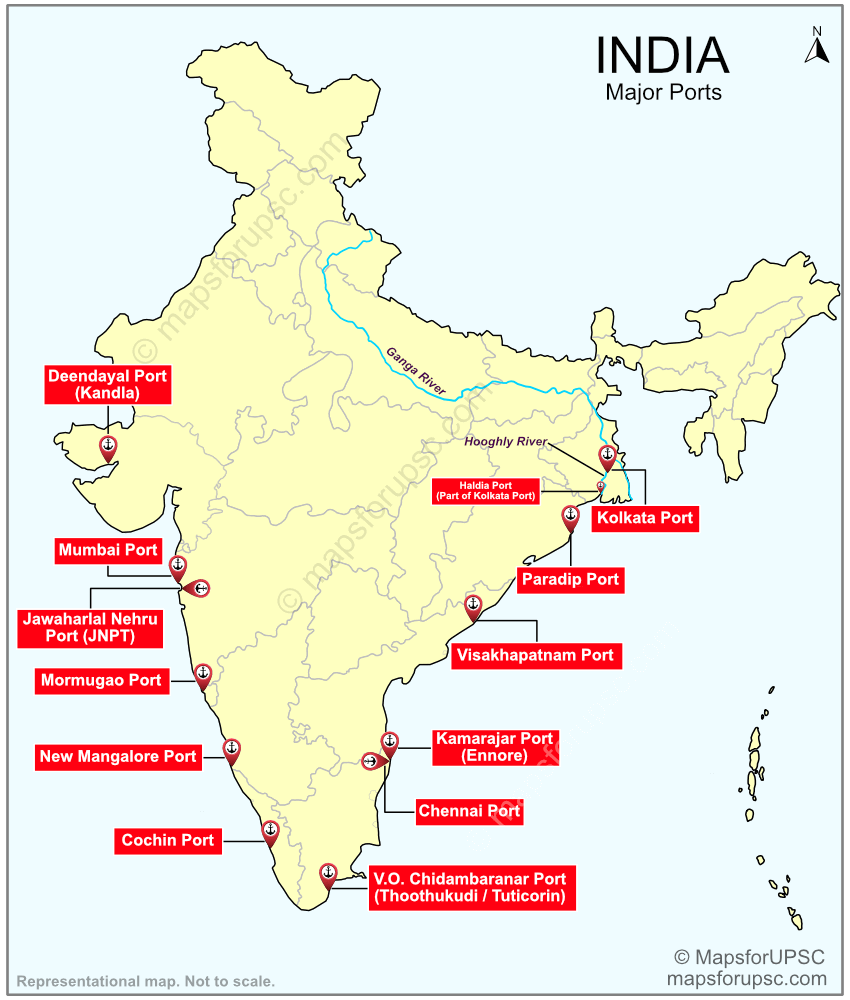
POINTS TO REMEMBER:
- There are 12 Major Ports (several sources mention 13 major ports, which is not true) in India out of which 6 are located on the East Coast and 6 on the West Coast.
- Please note that although Port Blair is mentioned as a Major Port in many sources, it is NOT a Major Port.
- Also, in some sources, the Kolkata Port and Haldia Port are mentioned as 2 separate Major Ports, which is not the case. They both come under one Major Port, that is, The Kolkata Port (Officially called the Syama Prasad Mookerjee Port).
- When in doubt, always refer to genuine government sources (if available) for information. You can check the Annual Report of the Ministry of Ports, Shipping, and Waterways to confirm this information yourself.
- Major Ports are owned and managed by the Central Government while Minor or other Non-Major Ports are owned and managed by the State Governments.
- Major Ports are under the Union List of the Constitution of India while the Non-Major Ports are under the Concurrent List.
- Galathea Bay Port (proposed 13th Major Port of India):
- The Galathea Bay Port (also known as the International Container Transshipment Port (ICTP)) is a proposed container transshipment port at Galathea Bay, Great Nicobar Island in the union territory of Andaman and Nicobar Islands
- In September 2024, it was officially notified as the 13th major port of India.
- Remember, since this port is only proposed and not yet operational, it is not officially listed as a major port.
- The Syama Prasad Mookerjee Port (Kolkata Port): It is the oldest operating port in India and also the only riverine Major Port in India. The port has twin dock systems – Kolkata Dock System (KDS) on the eastern bank and Haldia Dock Complex (HDC) on the western bank of river Hooghly.
- Located in Kutch District, the Deendayal (Kandla) Port is the largest port in India by volume of cargo handled. It is a natural and protected tidal port.
- The Mumbai Port is a natural port and the largest port in India in terms of size.
- The Jawahar Nehru Port (JNPT) is the largest container port in India, handling around 50% of the total container handled by all Major Ports in India.
- The Chennai Port is the oldest and the largest artificial harbour in India.
- For more details and key facts, please refer to the article on Major Ports in India.
10. UNESCO World Heritage Sites in India

POINTS TO REMEMBER:
- Currently, there are 44 UNESCO World Heritage Sites in India. Out of these, 36 are Cultural, 7 are Natural and 1 is Mixed Heritage Sites (Check the map above).
- India has the 6th largest number of UNESCO World Heritage Sites globally. With 61 Heritage sites, Italy has the highest number followed by China with 60 sites.
- The Ajanta Caves, Ellora Caves, Agra Fort, and the Taj Mahal, all included in the list of UNESCO World Heritage Sites in 1983, were the first sites from India to be added to the list.
- Maratha Military Landscapes of India included in July 2025 is the latest addition from India to UNESCO’s list. Moidams – the Mound-Burial System of the Ahom Dynasty in Assam was added in 2024.
- You must know the states to which these heritage sites belong.
- Also, a common type of question asked by UPSC in various exams (including UPSC Prelims, CAPF, etc. ) is to arrange certain sites/places from east to west or north to south and vice versa. So, knowing the general locations of these world heritage sites will also be useful.
- Please note that all 6 Hill Forts of Rajasthan come under one World Heritage Site. Similarly, the Mountain Railways of India which is counted as a single world heritage site has three branches: 1. The Darjeeling Himalayan Railway (listed in 1999), 2. The Nilgiri Mountain Railway (added in 2005), and 3. The Kalka–Shimla Railway (added in 2008).
- Check out the article on UNESCO World Heritage Sites in India to know more.
11. Natural Vegetation in India

POINTS TO REMEMBER:
- Forests in India are generally divided into the following groups:
- Tropical Evergreen and Semi Evergreen Forest
- Tropical Deciduous Forests
- Tropical Thorn Forests
- Montane Forests
- Littoral and Swamp Forests (Mangrove types)
- Know the rainfall and temperature requirements of these forests along with where they generally occur in India. You should also know some important species found in these forests and some specific features that are particularly related to these forests.
- Let us take Tropical Evergreen and Semi Evergreen Forests for example:
- Annual rainfall requirement: Above 200 cm.
- Mean annual temperature: Above 22°C.
- Occurrence: Western slope of the Western Ghats, hills of Northeastern region, Andaman & Nicobar Islands, etc.
- Species found: Rosewood, mahogany, ebony, etc.
- Features: The trees here can grow up to 60 meters or above. Since these forests remain warm and wet (humid) throughout the year, they have all kinds of natural vegetation, such as shrubs, bushes, small trees, tall trees, etc., giving them a well-stratified (multilayered) structure. These forests have a very dense forest cover, and thus, the sunlight hardly reaches the ground here.
- Semi-evergreen forests are found in the less rainy parts of these regions. The main species are white cedar, hollock, and kail.
- For more details please refer to the article on Natural Vegetation of India.
12. Biosphere Reserves in India

POINTS TO REMEMBER:
- Currently, there are 18 biosphere reserves in India. They protect larger areas of natural habitat than a typical national park or wildlife sanctuary, and often include one or more national parks or other protected areas, along with buffer zones.
- Out of the 18 Biosphere Reserves in India, 13 are a part of the World Network of Biosphere Reserves, based on the UNESCO Man and the Biosphere (MAB) Programme list.
- Nilgiri Biosphere Reserve, added to the list in 2000, was the first from India to be included in UNESCO’s Network of Biosphere Reserves. The Cold Desert Biosphere Reserve added in 2025, is the latest one.
- The Great Rann of Kutch (Gujarat) is the largest Biosphere reserve in India while Dibru-Saikhowa (Assam) is the smallest.
- Know the general location and states to which these Biosphere Reserves belong to.
- Questions have been asked to identify which protected areas (National Parks, Tiger Reserves, Wildlife Sanctuaries, etc.) are included within a particular Biosphere Reserve. If not all, you should at least cover those Biosphere Reserves that are in the news.
- Know the key faunas of these Biosphere reserves, especially of the ones that are in the news.
- 3 Biosphere Reserves in India share their area with two or more Indian States:
- Nilgiri Biosphere Reserve – Kerala, Karnataka, and Tamil Nadu.
- Achanakmar-Amarkantak Biosphere Reserve – Madhya Pradesh and Chhattisgarh.
- Agasthyamalai Biosphere Reserve – Kerala and Tamil Nadu.
- Check out the article on Biosphere Reserves in India to know more.
Important World Maps for UPSC
1. Countries Lying on the Equator

POINTS TO REMEMBER:
- The Equator (0°) is an imaginary line around the middle of the Earth that divides the planet into Northern and Southern Hemispheres.
- The Equator passes through 13 countries in 3 continents.
| Continents | Countries |
| South America (3) | 1. Ecuador, 2. Colombia, 3. Brazil |
| Africa (7) | 4. São Tomé and Príncipe, 5. Gabon, 6. Congo, 7. Democratic Republic of Congo, 8. Uganda, 9. Kenya, 10. Somalia. |
| Asia (3) | 11. Maldives, 12. Indonesia, 13. Kiribati (Oceania) |
- Out of these 13 countries, 11 are in direct contact with the equator. The landmasses of Maldives and Kiribati, however, do not touch the equator itself. Instead, the equator passes through the territorial water belonging to these islands.
- Remember the names of the countries in order, going from west to east.
- The Equator also passes through 3 major water bodies: the Pacific Ocean, Atlantic Ocean, and Indian Ocean.
2. Countries Lying on the Tropic of Cancer

POINTS TO REMEMBER:
- The Tropic of Cancer is an imaginary line lying at 23½° North of the Equator.
- It is also referred to as the Northern Tropic and is the northernmost latitude on Earth on which the Sun can be directly overhead (on June Solstice).
- The Tropic of Cancer passes through 17 countries in 3 continents.
| Continents | Countries |
| South America (2) | 1. Mexico, 2. Bahamas (Archipelago) |
| Africa (7) | 3. Western Sahara, 4. Mauritania, 5. Mali, 6. Algeria, 7. Niger, 8. Libya, 9. Egypt |
| Asia (8) | 10. Saudi Arabia, 11. United Arab Emirates, 12. Oman, 13. India, 14. Bangladesh, 15. Myanmar, 16. China, 17. Taiwan |
- Major water bodies through which the Tropic of Cancer passes through: Pacific Ocean, Gulf of Mexico, Atlantic Ocean, Red Sea, Arabian Sea (Indian Ocean), and Taiwan Strait.
3. Countries Lying on the Tropic of Capricorn

POINTS TO REMEMBER:
- The Tropic of Capricorn is an imaginary line lying at 23½° South of the Equator.
- It is also referred to as the Southern Tropic and is the southernmost latitude on Earth on which the Sun can be directly overhead (on December Solstice).
- The Tropic of Capricorn passes through 10 countries in 3 continents.
| Continents | Countries |
| South America (4) | 1. Chile, 2. Argentina, 3. Brazil, 4. Paraguay |
| Africa (5) | 5. Namibia, 6. Botswana, 7. South Africa, 8. Mozambique, 9. Madagascar |
| Australia (1) | 10. Australia |
- The Tropic of Capricorn also passes through 3 major water bodies: the Pacific Ocean, Atlantic Ocean, and Indian Ocean.
- Brazil is the only country through which both the Equator and the Tropic of Capricorn pass.
4. Countries Lying on the Prime Meridian

POINTS TO REMEMBER:
- A prime meridian is an arbitrarily chosen line of longitude in a geographic coordinate system at which the longitude is taken to be 0°. Together, a prime meridian and its anti-meridian (the 180° longitude) form a great circle that divides the Earth into two hemispheres: the Eastern Hemisphere and the Western Hemisphere.
- The Prime Meridian is sometimes also referred to as the Greenwich Meridian. However, these two lines differ slightly from each other.
- The Prime Meridian passes through 8 countries in 2 continents. Additionally, it also passes through the continent of Antarctica. So, in all, it passes through 3 continents.
| Continents | Countries |
| Europe (3) | 1. United Kingdom, 2. France, 3. Spain |
| Africa (5) | 4. Algeria, 5. Mali, 6. Burkina Faso, 7. Togo 8. Ghana |
- Remember the names of the countries in order, going from north to south (as given above). And yes, Togo comes before Ghana.
- Major water bodies through which the Prime Meridian passes through: Arctic Ocean, Norwegian Sea, North Sea, English Channel, Mediterranean Sea, Atlantic Ocean, and Southern Ocean.
- Algeria and Mali are the two countries through which both the Tropic of Cancer and the Prime Meridian Pass.
5. Major Deserts of the World

POINTS TO REMEMBER:
- A desert is a landscape that receives very little precipitation, generally less than 25 cm (about 10 inches) per year.
- Unlike the common notion, deserts are not always hot sandy landscapes. In fact, the two largest deserts in the world – the Antarctic Desert and the Arctic Desert are both cold deserts. Similarly, the Gobi Desert, the Patagonian Desert, the Karakum Desert, etc. are also cold deserts.
- The largest desert outside the pole is the Sahara Desert. It is a subtropical (hot) desert and thus it is the largest hot desert in the world.
- The Atacama Desert is the driest nonpolar desert in the world and the only hot desert to receive less precipitation than polar deserts. The almost total lack of precipitation is the most prominent characteristic of this desert. It is commonly known as the driest place in the world.
- For more key facts, please refer to the article on major deserts of the world.
6. Major Grasslands of the World

POINTS TO REMEMBER:
- Grasslands, as the name suggests are the area of land covered by vegetation dominated by grasses, with little or no tree cover.
- There are two main types of grasslands in the world:
- Temperate Grasslands: For example, Prairies in North America, Downs in Australia, and Pampas in South America.
- Tropical Grasslands (Savanna): For example, Campos in South America, African Savanna, and Australian Savanna.
- Tropical Grasslands have dry and wet seasons that remain warm all the time, while Temperate Grasslands have warm summers and cold winters, with temperatures that may go even below 0°C.
- For more key facts, please refer to the article on major grasslands of the world.
7. Major Mountain Ranges of the World

POINTS TO REMEMBER:
- The Andes is the longest continental mountain range in the world and the world’s highest range outside of Asia with an average height of about 4000 m.
- Know the countries that these mountain ranges lie in. For example, the Andes in South America extend from north to south through seven countries: Venezuela, Colombia, Ecuador, Peru, Bolivia, Chile, and Argentina.
- The Lithium Triangle is a region of the Andes that is rich in lithium reserves. Three countries that are part of the Lithium Triangle are Argentina, Bolivia, and Chile.
- The Himalayas and the Alps are examples of Young fold mountains, while the Appalachians and the Urals are examples of old fold mountains.
- The Ural mountain ranges act as a boundary between Europe and Asia.
- For more important facts, please refer to the article ‘Major Mountain Ranges of the World‘.
8. Major Rivers of the World

POINTS TO REMEMBER:
- River Nile is the longest river in the world followed by the Amazon River and Yangtze River.
- Amazon River is the Largest river (in terms of average water discharged at the mouth of the river), followed by the Ganges-Brahmaputra-Meghna River system.
- Lake Victoria is considered to be the source of the River Nile where it originates as the White Nile River.
- You should know where these major rivers finally drain into. For example, the Nile empties into the Mediterranean Sea, the Volga into the Caspian Sea, and River Zambezi into the Mozambique Channel (Indian Ocean).
- Questions can be asked to identify different countries (or how many countries) that a river passes through. Cover this aspect for at least those rivers that are in the news. For example River Mekong passes through 6 countries: China, Myanmar, Thailand, Laos, Cambodia, and Vietnam.
- Similarly, you should know if a river is taken to be an international boundary between two countries, especially if these countries are in the news. For example, River Amur forms a major part of the China-Russia boundary.
- For more rivers related facts, please refer to the article ‘Major Rivers of the World‘
9. Major Lakes of the World

POINTS TO REMEMBER:
- The Caspian Sea is the world’s largest inland body of water and shares its area between Europe and Asia. Its classification as either a lake or a sea has been a matter of both geographical and geopolitical debate.
- Lake Baikal, a freshwater lake located in Siberia, Russia is the deepest lake in the world (1,642 m).
- Lake Tanganyika in Africa is the longest lake in the world. This lake is shared among four countries—Tanzania, the Democratic Republic of the Congo (DRC), Burundi, and Zambia.
- The Great Lakes (also called the Great Lakes of North America), are a series of large interconnected freshwater lakes in North America that connect to the Atlantic Ocean via the Saint Lawrence River. These lakes are (From largest to smallest): Lake Superior, Lake Huron, Lake Michigan, Lake Erie, and Lake Ontario.
- Lake Superior (shared between the USA and Canada) is the largest lake in the world by area followed by Lake Victoria.
- For more important facts, please refer to the article ‘Major Lakes of the World‘.
10. Major Straits & Channels of the World

POINTS TO REMEMBER:
- A strait is a narrow passage of water that connects two seas or two other large bodies of water. It separates two large land masses through which it passes. A channel, on the other hand, is a relatively wider strip of water connecting two large water bodies. (Check on the map above: Strait of Hormuz and Mozambique Channel)
- Apart from knowing the locations of these straits & channels, you should also know which two water bodies they connect and which two landmasses they separate. For example, The Strait of Hormuz connects the Gulf of Oman and the Persian Gulf, while it separates Iran from Oman.
- Check out our article on Major Straits of the World for more details.
- Straits are often in the news: sometimes due to their presence in a particular shipping route, sometimes due to some military exercises held in and around these straits, and sometimes due to other strategically important reasons. Follow them thoroughly.
11. Mediterranean Region

POINTS TO REMEMBER:
- The Mediterranean Sea is bordered by 22 countries (including Palestine) and one territory (Gibraltar – a British Overseas Territory) spanning across Europe, Africa, and Asia.
- ‘Number’ of countries may not be asked as there is some ambiguity due to territorial disputes in certain areas. But questions have been and can be asked about the countries bordering the Mediterranean Sea.
Please refer to the article on Mediterranean Sea Bordering Countries to know the important facts about this region.
12. The Middle East and the Persian Gulf Region

POINTS TO REMEMBER:
- The Middle East is not officially defined as a distinct grouping, and various organizations may include different countries or territories in their definitions, or may not categorize it as a region at all. However, the countries/territories shown in green on the map above represent a consensus approximation of what is generally accepted as the Middle East region.
- For several decades now, the Middle East has consistently been at the forefront of key geopolitical issues. From an examination perspective, this region holds significant importance, not only for Prelims but also for the Mains exam. You should thoroughly follow the current affairs related to this region.
- You should also know the countries that border the major water bodies in and near the Middle East. For example, the Gulf of Aqaba is bordered by four countries – Egypt, Saudi Arabia, Jordan, and Israel, while the Gulf of Suez is bordered by only one country – Egypt.
- For more details, check out our article on Middle East Region.
13. Israel & Neighbouring Areas

POINTS TO REMEMBER:
- This is one of the most important regions in the Middle East and a major conflict zone in the world.
- You should have a good understanding of the Israel-Palestine conflict.
- The status of Jerusalem has been described as “one of the most intractable issues in the Israeli–Palestinian conflict” due to the long-running territorial dispute between Israel and the Palestinians, both of which claim it as their capital city.
- Most countries and organizations support that West Jerusalem and East Jerusalem should be allocated as capital cities to the Israelis and the Palestinians, respectively; this position has been endorsed by the United Nations, the European Union, and France, among others. Russia already recognizes East Jerusalem as the Palestinian capital and West Jerusalem as the Israeli capital.
- With respect to the Israel-Palestine conflict, India believes in a Two-State Solution and proposes the right to self-determination to both countries in a peaceful manner. However, the Indian government does not currently recognize Jerusalem as Israel’s capital. India is represented in Israel through an embassy in Tel Aviv.
- Port Said and Port Suez (Port Tawfiq) are the two ports at either end of the Suez Canal.
- Countries bordering the Dead Sea: Israel, Jordan, and Palestine.
- The Sinai Peninsula is the only part of Egypt that lies in Asia, the remaining part lies in Africa.
- The Golan Heights are a rocky plateau in the Levant region of Western Asia that was captured by Israel from Syria in the 1967 Six-Day War. The territory has been occupied by Israel since then and was subject to a de facto Israeli annexation in 1981. The international community, with the exception of Israel and the United States, generally regards the Golan Heights to be Syrian territory held by Israel under military occupation.
14. Nordic vs Scandinavian vs Baltic Countries

POINTS TO REMEMBER:
- The Nordic region is one of the most developed regions in the world.
- In most of the developmental and other major indices and reports, you will find the Nordic countries among the best performers. And so, these countries are often in the news.
- You should have clarity on which countries come under the Nordic, Scandinavian, and Baltic countries.
- As shown on the map above, there are 5 Nordic countries – Norway, Sweden, Denmark, Finland, and Iceland. Out of these five, the first three – Norway, Sweden, and Denmark are also called the Scandinavian countries. Please note that Finland and Iceland are Nordic but NOT Scandinavian.
- The Baltics is comprised of 3 countries in Northern Europe on the eastern coast of the Baltic Sea – Estonia, Latvia, and Lithuania.
- Nordic-Baltic Eight (NB8) is a regional co-operation format of 8 countries (5 Nordic and 3 Baltic) – Norway, Sweden, Denmark, Finland, Iceland, Estonia, Latvia, and Lithuania.
15. Eastern Europe Region

POINTS TO REMEMBER:
- The conflict between Russia and Ukraine in Eastern Europe has now been ongoing for over three years. You should know this region properly and follow the important current affairs related to it.
- Kaliningrad is a Russian exclave sandwiched between Poland and Lithuania on the southern coast of the Baltic Sea.
- St. Petersburg is a Russian port city on the Baltic Sea. It is a major trade gateway and financial and industrial center of Russia.
- Know the neighbouring countries of Ukraine and Russia. Apart from knowing the cities mentioned in the map above, you should also know other important cities that are in the news.
- Remember the NATO countries, especially those that border Russia or Ukraine.
- In 2023, Finland became the 31st country to join NATO. With this, there are now 6 NATO countries sharing borders with Russia – Norway, Finland, Latvia, Estonia, Poland, and Lithuania. Please note that Poland and Lithuania share border with the Kaliningrad region of Russia.
- Dnipro River is the longest river in Ukraine and it drains into the Black Sea.
- Kyiv, the capital city of Ukraine lies on the bank of the Dnipro River. Other important cities lying on the bank of this river are Chernobyl, Zaporizhzhia, and Kherson.
- The Kerch Strait connects the Sea of Azov to the Black Sea.
- In 2014, the Crimean peninsula was annexed by Russia, but most countries recognize Crimea as Ukrainian territory.
16. South China Sea

POINTS TO REMEMBER:
- The South China Sea is another major zone of conflict in the world. The conflict here is due to the overlapping territorial and maritime claims of several sovereign states, namely China, Taiwan, Philippines, Malaysia, Vietnam, and Brunei.
- The disputes involve the islands, reefs, banks, and other features of the South China Sea. Spratly Islands, Paracel Islands, and Scarborough Shoal are some of the most notable examples of such disputed territories.
- Study the above map properly. Also, remember other islands in the region. For example, Riau islands (Indonesia), Calamian islands (Philippines), and Hainan island (China). Please note that these are NOT disputed territories.
- The Pratas Island in the northern South China Sea is a coral island currently occupied and administered by Taiwan. China also claims the island, consistent with its broader claim over the entirety of Taiwan.
These were some of the important maps for UPSC preparation. As I mentioned at the beginning of the article, these maps are meant to ‘assist’ you in your preparation. However, it is crucial to study various other map-related topics as well. Other important maps to cover include Tiger Reserves, National Parks, Ramsar sites, Soils in India, Ocean Currents, etc.
Feel free to add value wherever needed to these 28 maps that I have provided above, but avoid overdoing it. Remember, there are other subjects to cover, and effective revision is essential. Allocate your time wisely.

118 thoughts on “28 Important Maps for UPSC Preparation (with PDFs) 2026”
Very well thought and very usefull for UPPSC 2026 exam . Thank u
Thank you, Rishi. 😊
Glad you found it useful for your UPPSC preparation. Wishing you all the best for the exam! 🙏
Hello sir, are these available in single pdf?
Hi Japhet. 😊
If you want this particular page as a PDF, you can simply press Ctrl + P on your computer (or use your browser’s Print/Share → Save as PDF option on mobile) to save it.
Thanks
Sir Maps is very very helpful for me
Thanks, Nikhil. 😊
Really glad the maps are helping you. All the best for your preparation. 🙏
Thankyouuuu soo much sir ! it has really helped me a lot.
Thank you, Khushmeet. 😊
Really glad it helped you. 🙏
An ineffable creation
Thank you so much.
Thank you, Arivazhagan. 😊
Really appreciate your words. 🙏
Thankyou sir🙏🙏🙏
You are welcome, Ritika. 😊🙏
Dhanyawaad sir 🙏🏻 parntu durbhagya se mai khud hi aise maps bana rha tha aur maine apne kai din barbaad kar diya, fir bhi achha hua ki aapke maps mujhe mil gaye jisse mere kai din save hogye 🤗🤗🙏🏻🙏🏻
Dhanyawaad, Balkrishn. 🙏
Achha laga ki aapko maps mil gaye aur aapka samay bach gaya. 😊
All the best for your preparation. 👍
Was really too worried. Amazing work. Thank u so so so much ✨Means a lot. This is a perfect one stop solutions for maps. No where could I find the right collection of maps. Thanks again
Thank you so much, Aditi. 😊
I am really glad the maps could help and that you found everything in one place. Thanks again for the kind words. 🙏
It is like one stop solution for everything required to learn in the world and Indian map. Thanks u so much, Means alot.
Thank you, Tanya. 😊
Really glad you found it useful and all in one place.
Thanks Bhaiya, you deserve a 🫶 from us..!
Thank you, Pritam. 😊
Really appreciate it. 🫶
चरणस्पर्श गुरूवर्य .. GRATEFUL 🙏🙇♂️
Thank you, Tushar. 🙏
Your respect means a lot. 😊
Thank you mr.Subodh sir, presenting this for aspirants. Its really helpful🙏🏻
Thank you, Samrat. 🙏 I am glad you found it helpful.
its super good , can you change the capital of andhaman island in the map
Thank you so much, Loga, for pointing this out.
Yes, the capital of Andaman has been renamed to Sri Vijaya Puram (earlier Port Blair). I will update it in the map very soon.
Thanks again for your valuable feedback. 😊
Thank You Soo Much Sir,
Most Important topic of Every Exam✅🫡🙏
Thank you, Amit. 🙏
Yes, maps are indeed one of the most important parts of many exams. Glad you found it helpful. 😊
Thank you brother from Haryana
Thank you so much, Sushil. 🙏
Best wishes to you from here as well!
Great content sir, very helpful and updated maps. Can you please make maps of places in news, conflict areas etc. for upcoming prelims 2026?
Thank you so much, Anmol, for your kind words 😊 Glad you found the content and maps helpful.
At present, my main focus is on completing the static maps and content. Once that is done, current affairs–based maps (places in news, conflict areas, etc.) are next in the pipeline. However, that may take some time.
If everything goes as planned and I’m able to complete it, it will most likely be released around May. Before that, it’s quite improbable—but I will definitely try my best to make it happen.
Thanks again for the encouragement and support!
Ok Sir, thank you once again for the wonderful maps and the efforts that you are putting in
You are most welcome, Anmol 🙂
Wishing you all the very best for your preparations.
In river map pdf have some mistakes godavari river not originate from Lake rakshastal . Please correct this
Thank you for pointing this out, Sonam.
We have checked both the website content and the PDF maps, and there is no mention of the Godavari River originating from Lake Rakshastal. The origin is correctly shown.
If you are referring to any specific map or page, please let us know—we will be happy to recheck and correct it if required. 🙏
Thank you once again, Sonam. After rechecking in detail, we found that while the website content is correct, there was an unintentional error in the MapsBuzz magazine, where the origin was mistakenly mentioned during data compilation.
We sincerely regret this oversight and will correct it in the next update. Thank you for helping us improve the quality of our content. Your feedback is truly appreciated. 🙏
Finally i found a website on which i rely for my all geography mapping. Thank you so much for your effort. Gratitude
Thank you so much, Priti. I am really glad the maps are helpful to you. Truly appreciate your kind words and gratitude. 🙏
Thanks sir . It is really very helpful . Thanks alot😊😊
You are welcome, Vandana. Glad you found it helpful! 😊
Im not going for upsc but actually this free website is actually good .
And I’m wondering why there is not even a single ad.
Hats off
Thank you so much, Subham, for your kind words and encouragement. 🙏
I am really glad you found the website useful.
I have kept it mostly ad-free so that students can study without distractions. During my own preparation, I faced many unnecessary ads and pop-ups, so I decided to avoid that here as much as possible. Currently, the main revenue comes from our MapsBuzz eBook, whose banner you can see on most article pages.
Thanks again for your support. 😊
I am so glad i found this.. i am not UPSC aspirant but from GK perspective this is extremely useful to me.. thank you so much sir
Thank you, Sushmit! Happy it helped you too. 😊🙏
It was amazing content and very help full for me and easily understanding
thank you so much for delivered this such fabulous content👍👍
Thank you so much, Arun! Glad to know you found it helpful and easy to understand. 😊
Hey Subodh,
That’s really fantastic piece of work and truly very helpful for a full time working person like me.
I would like to request you to share importable kml files which i can import in Google earth (If you have made it, I’m Happy to buy even if it is paid)
Thank you so much, Amit. I’m really glad you found the maps helpful. At the moment, I haven’t created KML files, but your suggestion is very valuable and I will definitely keep it in mind for future updates. Truly appreciate your support and encouragement!
Good job Sir/Madam
This is the best way to learn geography
Thanks a lot for it
Thank you so much, Gursewak! Really glad to know you found it helpful for learning geography.
Very useful and easy to understand.
Thank you sir….
Thank you so much, Ambika. I’m really glad you found it useful and easy to understand.
THANK YOU SO MUCH BUDDY FOR THIS MAPS.
MAY GOD GIVE YOU EVERYTHING YOU WANT IN YOUR LIFE MAN
Thank you so much, Samrat! Your blessings and kind words mean a lot. Truly grateful 🙏 Wishing you the very best in life too!
Thank you so much for helping us and also make the high quality PDF downloadable easily.
You are very welcome, Shivanshu! 😊 I’m glad you found the PDF helpful and easy to access.
Sir your great efforts made my preparation easier because it takes lot of time to search every ap on Google. Also it takes lot of time to draw such handwritten maps. Thankyou so much sir.🙏🙏🙏🙏
Thank you, Manjeet! I am really happy to hear that the maps are saving you time and helping in your preparation. Keep up the hard work and stay consistent—wishing you all the success ahead! 🙏😊
Sir, your precious efforts really made things easy!
We people are grateful to have this website with us.
Thankyou sir , thankyou for your precious efforts.
Thank you so much, Vedika! Your words truly mean a lot. I am really glad the website is helping you. Wishing you the very best in your journey—keep learning and keep going! 😊
Tysm sir
This eBook PDF has made my week.
You are most welcome, Harjas!
So glad to hear that the eBook made your week — that truly means a lot. 😊
Wishing you all the best in your preparation!
You have done a great job. Can’t thank you enough.
Thank you so much, Gunjan! 😊 Your words truly mean a lot. I am really glad the work is helping you—wishing you all the best in your preparation! 🙌
Thankyou sir. The ULTIMATE one stop solution for maps ,very helpful.
Thank you, Anushka! Glad you found it helpful—it means a lot.
THANK YOU SO SO MUCH
You are very welcome, Mannan!
Sir this is best for every aspirant also for revision. Thank you so much sir🤗
You are welcome, Tiasha! Thank you for your kind words!
This is it! ONE STOP SOLUTION TO mapping. Thanks Sir for this
You are welcome, Nayan! I am glad you found it helpful!
Hii Sir this side Kajal … Thank you so much for this one stop solution for Mapping …. Really this is amazing and very helpful ☺️🤗
🤗
Hi Kajal! 😊 Thank you so much for the kind words—it truly means a lot. I’m really glad you found the mapping resource helpful. Wishing you the best in your preparation!
Thank you so much for this! it’s really helpful and absolutely refreshing to find something not stuck behind a paywall.
You are welcome, Debosmita! I am glad you found it helpful. And thank you so much for your kind words!
Absolute Perfection!! Actually it is very helpful for the studies.
Thank you, Pruthve. 😊
Really happy to know you found it helpful for your studies. Thanks for the kind words. 🙏
Thanks you so much. It is very helpful to understand world and Indian geography.
You are welcome, Subham! I am glad you found it helpful.
It is really very helpful for my this journey of preparation..
I have no words to pay thanks to you.
I am heartedly thankful to you for this help.
Your this work is really great 👍.
May God always keep his blessings with you.
Lots of love from my side.❤️
You are welcome, Anuja! I am glad you found it helpful. And thank you so much for your kind words!
Very helpful. Thanks a lot Maps for Upsc
You are welcome, Andrio! I am glad you found it helpful.
Is it enough for mapping or something else required?
Hello Ruchi! These are the basic maps that you must cover, but are not enough when it comes to UPSC CSE. There are several other maps that you need to cover, including current affairs based. You may refer to this article to get more clarity: https://mapsforupsc.com/how-to-study-maps-for-upsc/
Thank you note dropping here……
So generous and thoughtful of you sir.
Suddenly, I got your website, and it is fabulous. Thank you so much sir for your wonderful work. KEEP WORKING
You are welcome, Priyanka! I am glad you found the work helpful! And thank you for your kind words.
Thank you sir its very usefull
Sir thank u
You are welcome, Dhanmani!
very helpful sir, thank you so much
are these available in one pdf?
You are welcome, Ravi! I am glad you found it helpful! ☺️
And not yet Ravi. We are working on it and most of our materials will be available as a single PDF soon! Stay tuned. Thanks
Thank you so much sir, it really helpful for us 🙏🙏
Very helpful 💐
I am glad you found it helpful! ☺️
Thanks for this ☺️
You are welcome, King! ☺️
sir can u please point out about the diff climatic zones in the world and the india as per the koeppen’s theory
Hi Madhavan! We’re currently working on various maps, including topics like climatic zones. Stay tuned!
Very Good work sir g.shorts notes almost geography completed.Best method of revision. Thanks sir
You are welcome, Shafquat!
I am glad you found it helpful!
These are extremely helpful. gratitude!!!
Thank you so much for your kind words! I’m glad you found the article helpful! 😊
Thank you so much for providing detailed informations in arranged way.
You are welcome, Ajay! I am glad you found it helpful!
There are 28 maps, I have seen all the maps. Easier and faster to understand than text reading. Thank you for provided🙏🙏🙏. Keep it up sir.
You are welcome, Rupsingh!
Very useful. Thank you so much..
You are welcome, Jamaludheen!!
You are doing great work .😀
I am not preparing for any big exam but it’s helpful.
Thank you, Arti! I am glad you found it helpful!
Amazing work Subodh! Thank you for putting it out. Gratitude!
Thank you so much, Shikha! I really appreciate your kind words and support 😊
Thankyou sir.please share your app link sir.
You are most welcome Neeku.
Currently we do not have any app yet. All our contents are available here in this website itself. Thank you for your interest.