The Thar Desert, also known as the Great Indian Desert, is one of the largest subtropical deserts in Asia. It is one of the most important physical features of India and forms a significant topic in Geography for UPSC and other competitive examinations.
The desert is known for its sandy terrain, sand dunes, sparse vegetation, extreme climate, and unique ecosystem. Despite harsh environmental conditions, it supports a large population and has rich cultural and ecological significance.
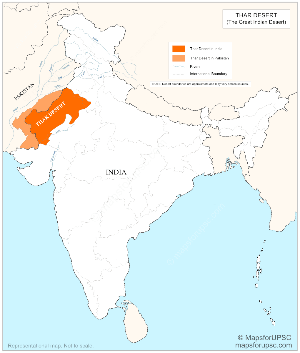

Location and extent
The Thar Desert is spread mainly across western Rajasthan, and also extends into Gujarat, Haryana and Punjab in India. Across the border, it continues into Sindh and Punjab in Pakistan. Most of the desert lies in India, while a smaller part extends into Pakistan.
Its total area is about 200,000 sq km, which makes it one of the largest subtropical deserts in the world. It is also an important example of a desert that is not confined to a single country.
The desert is bordered by:
- the Indus River plain to the west,
- the Punjab Plain to the north and northeast,
- the Aravalli Range to the southeast,
- and the Rann of Kachchh to the south.
Key Features of the Thar Desert
| Feature | Description |
|---|---|
| Relief | The Thar Desert has a varied surface with sand dunes, sandy plains, rocky tracts, and low-lying depressions. It is not a uniform sheet of sand. |
| Dune types | The region contains barchan dunes, longitudinal dunes, and stabilized dunes. Some dunes are very large and actively shaped by wind. |
| Soil | The soil is mostly sandy, loose, and low in humus. In several places, it is also saline and poor in fertility. |
| Climate | It has an extreme hot desert climate, with summer temperatures often rising to around 45°C to 50°C, while winter nights can be much cooler. |
| Rainfall | Rainfall is scarce and irregular. Most of the desert gets very little annual rain, and some areas remain dry for long periods. Drought conditions are common. |
| Water availability | Surface water is limited. The Luni River is the main river associated with the Indian side of the desert. Most other streams are seasonal, and water is obtained from wells, canals, tanks, and groundwater. |
| Vegetation | Natural vegetation is sparse and drought-resistant. Thorny bushes, grasses, and xerophytic trees are common. |
| Fauna | The desert supports adapted wildlife such as chinkara, blackbuck in some areas, desert fox, Indian wild ass in fringe zones, Great Indian Bustard, spiny-tailed lizard, and several reptiles and birds. |
| Protected Areas | Desert National Park and Tal Chhapar Sanctuary (an Important Bird Area) are some important protected areas in the Thar Desert. |
| Human use | The region supports pastoralism, irrigated farming, and limited dryland agriculture. Settlement is concentrated near water sources. |
| Mineral Resources | The Thar Desert region is rich in minerals and energy resources. Important minerals found here include coal, gypsum, limestone, salt, bauxite, and silica, which add to the economic importance of the desert |
Formation of the Thar Desert
The exact origin of the Thar Desert is still debated among geographers and geologists. However, several factors are believed to have contributed to its formation.
- Rain Shadow Effect: The Aravalli Range runs parallel to the southwest monsoon winds. As a result, the monsoon winds do not rise significantly, leading to very little rainfall in western Rajasthan.
- Distance from the Sea: The region lies far from major moisture sources, especially during much of the year.
- Subtropical High Pressure: Descending dry air in the subtropical belt discourages cloud formation and rainfall.
- Geological and Climatic Changes: Long-term climatic changes and drying trends over thousands of years also contributed to desertification.
Indira Gandhi Canal and Its Importance
The Indira Gandhi Canal, formerly known as the Rajasthan Canal, is one of the largest irrigation projects in India and has played a major role in transforming parts of the Thar Desert. The canal originates from the Harike Barrage in Punjab and carries water from the Sutlej and Beas rivers into the arid regions of northwestern Rajasthan.
- It has made irrigation possible in large parts of western Rajasthan.
- It supports agriculture in dry areas where rainfall is very low.
- It has helped in the settlement of people in previously sparsely populated desert zones.
- It has improved the availability of drinking water in many villages and towns.
- It has contributed to regional development by supporting farming, livelihoods, and related economic activities.
However, excessive irrigation in some regions has also led to problems such as waterlogging and soil salinity, creating environmental challenges in the desert ecosystem.
