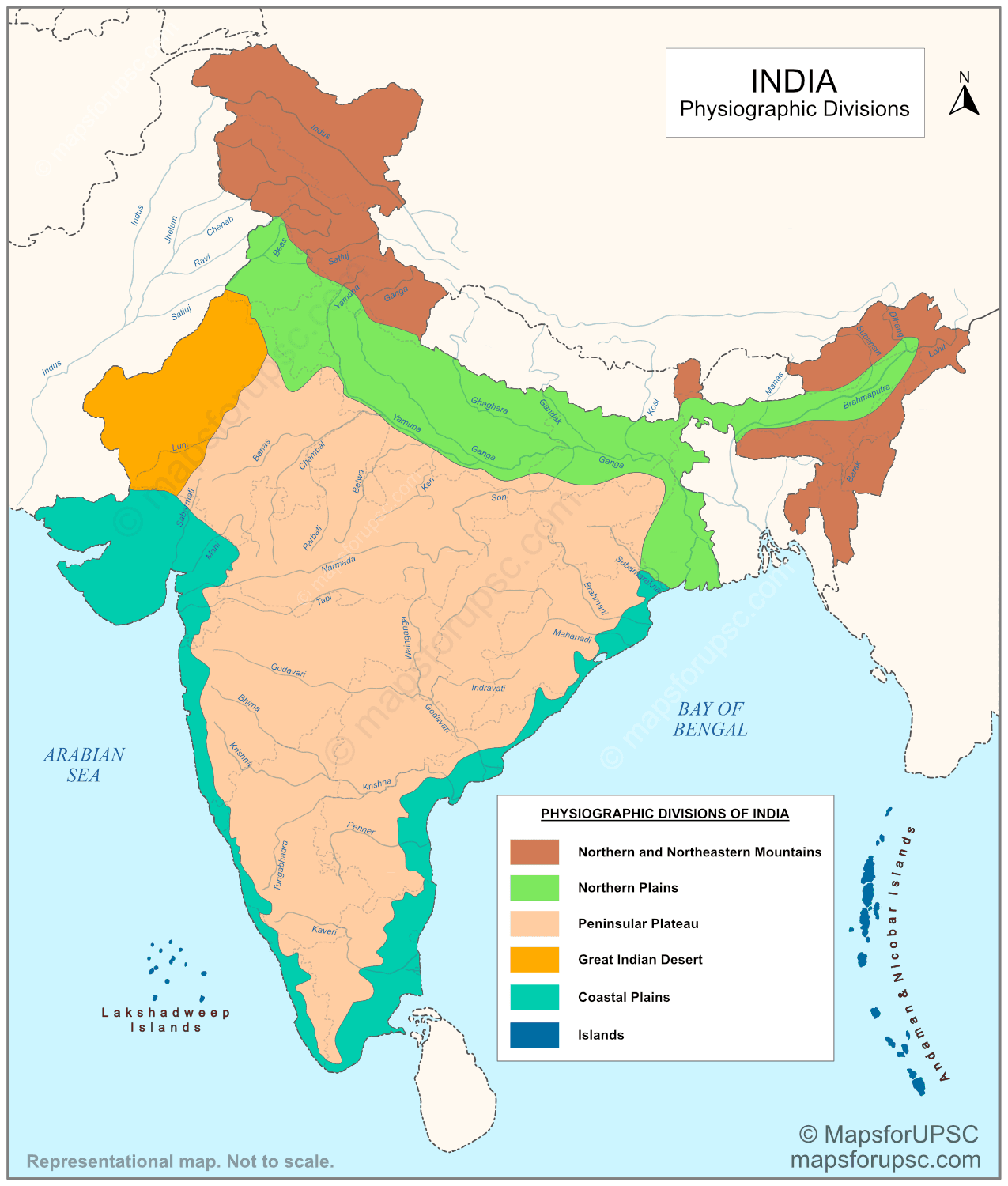
The physical landscape of India is commonly grouped into six major physiographic divisions:
- Northern and Northeastern Mountains
- Northern Plains
- Peninsular Plateau
- Great Indian Desert
- Coastal Plains
- Islands
Important Notes:
- The term ‘Northern and Northeastern Mountains‘ is often referred to simply as the Himalayan Mountains or the Himalayas in many geography sources. All these usages are acceptable and refer broadly to the same physiographic region.
- The exact boundaries and sub-regional divisions within these major units may vary slightly across different sources, especially in the case of the Peninsular Plateau and Coastal Plains.
- For clarity and conceptual understanding, this article focuses only on the six major physiographic divisions. The finer sub-divisions are discussed separately in dedicated articles.
1. The Northern and Northeastern Mountains
The Northern and Northeastern Mountains form the northernmost physiographic division of India. They consist primarily of the Himalayan mountain system along with its eastern extension into the Purvanchal hills.
These are geologically young fold mountains and are among the highest and most rugged mountain ranges in the world. They act as a natural barrier and play a crucial role in shaping India’s climate and drainage system.
Key features:
- Geologically young fold mountains
- Extend from the Indus region in the west to the Brahmaputra in the east
- Include parallel ranges with deep valleys
- Eastern extension forms the Purvanchal hills
2. The Northern Plains
The Northern Plains (also commonly referred to as the Indo-Gangetic-Brahmaputra Plains) were formed by the alluvial deposits of the Indus, Ganga and Brahmaputra river systems and their tributaries. They cover about 7 lakh sq km, are highly fertile, and are among the most densely populated regions of India.
Key features:
- Formed by river deposition over a long period
- Composed of fertile alluvial soil
- Broad, flat and highly suitable for agriculture
- Supports very high population density
3. The Peninsular Plateau
The Peninsular Plateau is an ancient tableland composed mainly of old crystalline, igneous and metamorphic rocks. It represents one of the most stable landmasses of India and is broadly divided into the Central Highlands and the Deccan Plateau.
Several smaller plateaus form part of this region, including the Malwa Plateau, Bundelkhand Plateau, Chota Nagpur Plateau, Telangana Plateau and Karnataka Plateau.
Key features:
- One of the oldest and most stable landmasses of India
- Composed mainly of hard crystalline rocks
- Characterised by broad and shallow valleys with rounded hills
- Rich in mineral resources and important for industrial development
- Drained by both east-flowing and west-flowing rivers
For a detailed explanation of its divisions, features and map, see our article on the Peninsular Plateau of India.
4. The Great Indian Desert
The Indian Desert lies to the west of the Aravalli Hills. It is an undulating sandy plain with dunes, very low rainfall of below 150 mm a year, and sparse vegetation. Luni is the only large river in this region.
Key features:
- Arid region with very low rainfall.
- Sandy surface with dunes.
- Sparse vegetation cover.
- Luni is the main river.
5. The Coastal Plains
The Coastal Plains are narrow low-lying strips along the Arabian Sea in the west and the Bay of Bengal in the east. They lie between the coastal mountain ranges and the sea, and are divided into the Western Coastal Plains and the Eastern Coastal Plains.
The western coast is generally narrow and lies between the Western Ghats and the Arabian Sea, while the eastern coast is broader in many places and includes major deltaic regions.
Key features:
- Narrow low-lying plains along both eastern and western coasts
- Western coast includes Konkan, Kanara and Malabar sections
- Eastern coast includes Utkal, Andhra and Tamil Nadu plains
- Eastern coastal plains are broader and marked by large river deltas
- Important for agriculture, ports, fisheries and trade
For a detailed explanation of their divisions, features and map, see our article on the Coastal Plains of India.
6. The Islands
India has two island groups: Lakshadweep in the Arabian Sea and Andaman & Nicobar in the Bay of Bengal. Lakshadweep is a coral island group close to the Malabar coast, while the Andaman & Nicobar Islands are larger, more scattered, and strategically important.
Key features
- Two major island groups.
- Lakshadweep is of coral origin.
- Andaman & Nicobar have strategic importance.
- Both support rich biodiversity.
Summary of Physiographic Divisions of India
| Division | Broad Location | Key Features & Facts |
|---|---|---|
| Northern & Northeastern Mountains | Along the northern border from Jammu & Kashmir to Arunachal Pradesh | – Young fold mountains, high relief, parallel ranges – Source of major rivers (Indus, Ganga, Brahmaputra); act as climatic barrier |
| Northern Plains | Between Himalayas and Peninsular Plateau | – Flat, fertile alluvial plains – Formed by Indus-Ganga-Brahmaputra system; highly populated and agriculturally productive |
| Peninsular Plateau | South of Northern Plains, covering central and southern India | – Old crystalline rocks, stable landmass, plateau region – Rich in minerals (coal, iron, mica); includes Chota Nagpur Plateau (mineral belt) |
| Great Indian Desert | Western India, mainly Rajasthan, west of Aravallis | – Arid, sandy plains with dunes, low rainfall – Indira Gandhi Canal supports irrigation; Luni is main river |
| Coastal Plains | Along Arabian Sea (west) and Bay of Bengal (east) | – Narrow plains, delta formation (east coast) – Eastern coast has large deltas (Godavari, Krishna, Kaveri); western coast has natural ports |
| Islands | Arabian Sea (Lakshadweep) and Bay of Bengal (Andaman & Nicobar) | – Coral (Lakshadweep) and tectonic/island arc (Andaman & Nicobar) – Andaman & Nicobar are strategically important; Indira Point = southernmost point of India |
Significance of the Six Physiographic Divisions
These divisions matter because each one plays a different role in India’s geography and economy. The mountains are major sources of water and forest wealth; the northern plains are the granary of the country; the plateau is a storehouse of minerals; and the coastal regions and islands support fishing and port activities.
Quick Revision Points
- Northern & Northeastern Mountains: young fold mountains.
- Northern Plains: fertile alluvial plains of major river systems.
- Peninsular Plateau: ancient rocky tableland, rich in minerals.
- Indian Desert: arid sandy region west of the Aravallis.
- Coastal Plains: narrow strips along both coasts, important for trade and agriculture.
- Islands: Lakshadweep and Andaman & Nicobar, with ecological and strategic value.
