The Peninsular Plateau of India is an ancient, stable landmass that occupies much of central and southern India and forms one of the six major physiographic divisions of the country.
It is an uplifted, largely table-land area made mainly of hard crystalline rocks and dissected by rivers into a series of plateaus, hill ranges, and shallow valleys, making it important both physically and economically for India.
This article provides a comprehensive overview of the major Peninsular plateaus of India, their divisions, key features, associated rivers, and a free downloadable PDF map, useful for competitive examinations such as UPSC and State PCS.
Location, Extent and Boundaries
- The Peninsular Plateau is roughly triangular in shape, with its broad base along the southern edge of the Indo-Gangetic Plain and its apex near Kanyakumari.
- It covers about 16 lakh sq km, extending across most peninsular states including Maharashtra, Karnataka, Telangana, Andhra Pradesh and Tamil Nadu, and parts of Gujarat, Madhya Pradesh, Chhattisgarh, Odisha and Jharkhand, along with some north-eastern uplands.
- The plateau is bounded by:
- Indo-Gangetic plains in the north
- Aravali range in the northwest
- Western Ghats in the west
- Eastern Ghats in the east
- It gradually merges with the coastal plains of India towards the surrounding seas.
- The Narmada and Tapi rivers broadly divide the plateau into two major parts:
- Central Highlands (north)
- Deccan Plateau (south).
Geological Background and General Features
- The Peninsular Plateau is part of the ancient Gondwana landmass and represents one of the oldest and most stable geological regions of India.
- It is mainly composed of igneous and metamorphic rocks such as granite, gneiss and schist, along with large basaltic lava formations of the Deccan Traps in the west and northwest.
- The average elevation ranges between 600–900 metres, though it varies across different regions.
- The plateau generally slopes from west to east, which explains why many major rivers such as the Mahanadi, Godavari, Krishna and Kaveri flow towards the Bay of Bengal.
- Over time, rivers have deeply dissected the plateau, forming broad valleys, rounded hills and several smaller plateaus and uplands.
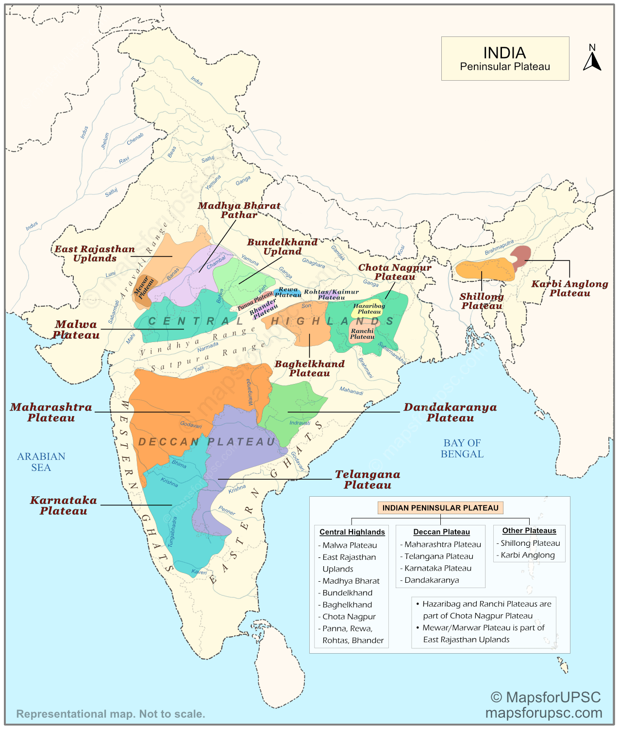
Major Divisions of the Peninsular Plateau
For convenience, the Peninsular Plateau of India is usually divided into three broad physiographic units:
- Central Highlands (north of the Narmada)
- Deccan Plateau (south of the Narmada)
- Northeastern/Other Plateaus (Northeast regions)
Note on Plateau Classification:
- The exact classification of plateau divisions in the Peninsular region may vary across different geography sources. Some authors include certain plateaus within broader divisions, while others treat them as separate physiographic units.
- For example, the Chota Nagpur Plateau is sometimes considered part of the Central Highlands, while other sources describe it as a separate eastern plateau region.
- For examination purposes, aspirants should focus mainly on the location, key features, drainage patterns, and geological characteristics of each plateau, rather than the exact classification used by different sources.
Overview Table: Major Divisions and Key Sub‑units
| Division | Broad Location | Important Plateaus | Key Facts |
|---|---|---|---|
| Central Highlands | North of Narmada, between Aravalli and Chota Nagpur | Malwa Plateau, East Rajasthan Uplands, Madhya Bharat Pathar, Bundelkhand Upland, Baghelkhand, Chota Nagpur Plateau, Vindhyan scarplands (Panna–Rewa–Bhander–Rohtas) | Ancient, largely relict highlands; slope from southwest to northeast; important for Chambal–Betwa–Ken river systems and mineral resources in Chota Nagpur. |
| Deccan Plateau | South of Narmada, covering most of peninsular India | Maharashtra Plateau, Karnataka Plateau, Telangana/Rayalaseema Plateau, Dandakaranya–Bastar Uplands | Volcanic (Deccan Traps) origin in large parts; bounded by Western and Eastern Ghats; gentle eastward slope; drained by Godavari, Krishna, Kaveri and their tributaries. |
| Other Plateaus | Northeast region | Shillong (Meghalaya) Plateau, Karbi Anglong Plateau | Fragment of Peninsular block separated by Garo–Rajmahal Gap; composed of ancient crystalline rocks; supports high rainfall and lateritic soils. |
Central Highlands
The Central Highlands form the northern segment of the Peninsular Plateau lying to the north of the Narmada River. They extend from the Aravalli Range in the west to the Chota Nagpur Plateau and Rajmahal Hills in the east, covering much of central India.
The region is broader in the west and narrower in the east, and the general slope is from southwest to northeast.
Drainage of the Central Highlands:
- Major rivers – Chambal, Sind, Betwa, Ken, Son and Damodar – originate in or traverse the Central Highlands.
- Most rivers flow from southwest to northeast (towards the Ganga basin), reflecting the general slope of the region and creating badlands and ravines in their lower courses, especially along the Chambal valley.
Following are the important Plateaus and Uplands of Central Highlands:
1. Malwa Plateau
- Lies mainly in western and central Madhya Pradesh and adjoining southeastern Rajasthan, between the Aravalli belt and the Vindhyan uplands.
- Largely built of Deccan Trap basalts; extensively covered by black (regur) soils in many parts.
- A rolling tableland with a general slope from southwest to northeast; elevation falls roughly from about 600 m in the south to about 500 m in the north.
- Drained chiefly by Chambal and its tributaries (Kali Sindh, Parbati) and by rivers like Betwa and Ken that flow northeast to join the Yamuna → Ganga system. (Some marginal drainage near the plateau edges connects with west-flowing basins.)
- The Chambal ravines — pronounced badland topography in the northern part, an important example of soil erosion.
- Fertile black soils support intensive agriculture (cotton and food crops); the plateau is agriculturally important for the region.
- Remember Malwa as a basaltic, north-sloping plateau marked by Chambal’s ravines and major tributaries (Chambal, Sindh, Parbati, Betwa, Ken).
2. East Rajasthan Uplands
- Situated to the east and southeast of the Aravalli Range in Rajasthan. The region gradually merges with the Malwa Plateau in the southeast and with the Ganga plains towards the northeast.
- A series of rocky and stony uplands and plateaus, often referred to as the Mewar–Marwar Plateau in some texts. The average elevation ranges between 250–500 m, with a general slope towards the east.
- Composed mainly of sandstones, shales and limestones of the Vindhyan system.
- Drained largely by the Banas River and its tributaries, which originate in the Aravalli hills and eventually join the Chambal River.
- Forms an important transition zone between the arid Thar Desert region to the west and the more humid plateau regions of Malwa and Bundelkhand to the east.
- Remember it as the eastern upland extension of the Aravalli region, drained mainly by the Banas–Chambal river system.
3. Madhya Bharat Pathar
- A plateau region in northern Madhya Pradesh, lying roughly between the Chambal valley and the Bundelkhand upland.
- Characterised by gently undulating plateau surfaces, with shallow valleys and thin soil cover in many places.
- Much of the region supports scrub vegetation and dry farming, reflecting relatively thin soils and semi-arid conditions.
- Acts as a transition zone linking the Malwa Plateau in the south with the Ganga plains in the north.
- Remember it as a small plateau belt between Malwa and Bundelkhand, forming part of the Central Highlands system.
4. Bundelkhand Upland
- Lies east of the Madhya Bharat Pathar, covering parts of southern Uttar Pradesh and northern Madhya Pradesh. It is bounded by the Yamuna River in the north, Malwa Plateau in the south, and Vindhyan uplands in the east and south-east.
- Built mainly of very old granite and gneiss rocks, often referred to as the Bundelkhand gneiss complex.
- A dissected upland with an average elevation of about 300–600 m. The surface slopes gently northwards towards the Yamuna River.
- Characterised by numerous low hillocks, rocky outcrops and an undulating surface, formed due to long-term erosion.
- Drained by rivers such as Betwa, Dhasan and Ken, which flow northwards to join the Yamuna.
- Remember Bundelkhand as an ancient granite-gneiss upland between the Yamuna and the Vindhyas, dissected by Betwa–Ken rivers.
5. Baghelkhand Plateau
- Lies east of the Bundelkhand Upland, covering parts of eastern Madhya Pradesh and northern Chhattisgarh. It is bounded by the Son River valley in the north and by uplands associated with the Maikal and Mahanadi basins in the south.
- Composed mainly of sandstones and limestones of the Vindhyan system in the west, while granite and older crystalline rocks occur towards the east.
- The plateau is uneven and dissected, with elevations generally ranging from about 150 m to over 1000 m.
- The central part of the plateau forms an important watershed between the Son River (Ganga basin) in the north and the Mahanadi basin in the south.
- Remember Baghelkhand as a Vindhyan plateau east of Bundelkhand that forms a major Son–Mahanadi drainage divide.
6. Vindhyan Scarplands: Panna–Rewa–Bhander–Rohtas
- Located along the Vindhya Range in parts of Madhya Pradesh and adjoining regions, forming a chain of tablelands between the Central Highlands and the northern plains.
- Includes a series of flat-topped plateaus such as Panna, Rewa, Bhander and Rohtas, separated by steep escarpments and valleys.
- Mainly composed of horizontal sandstones and limestones of the Vindhyan system, giving rise to characteristic tableland topography.
- These plateaus represent the escarpment zone of the Vindhyan ranges, important examples of structural plateaus in central India.
7. Chota Nagpur Plateau
- Forms the north-eastern extension of the Peninsular Plateau, covering most of Jharkhand and adjoining parts of northern Chhattisgarh, western Odisha and the Purulia region of West Bengal.
- The plateau has an average elevation of about 700 m, with a rugged and dissected surface. It is composed of several smaller plateaus such as the Ranchi Plateau and Hazaribag Plateau.
- Made mainly of ancient crystalline rocks and Gondwana formations, making the region extremely rich in coal, iron ore, manganese, bauxite and mica. Because of this mineral wealth, it is often called the “storehouse of minerals of India.”
- The plateau is drained by several rivers such as the Damodar, Subarnarekha, North Koel, South Koel and Barkar, producing a largely radial drainage pattern. The Damodar River flows through the middle of the plateau in a rift valley, where major Gondwana coalfields are located.
- Sub-plateaus:
- The Hazaribag Plateau, north of the Damodar.
- The Ranchi Plateau, south of the Damodar.
- The Rajmahal Hills, forming the north-eastern edge of the plateau, consist mainly of basaltic lava flows and rise to about 400–500 m.
- Remember Chota Nagpur as a mineral-rich Gondwana plateau with radial drainage and important sub-plateaus like Ranchi and Hazaribag.
Deccan Plateau
The Deccan Plateau lies to the south of the Narmada River and forms the largest part of the Peninsular Plateau.
It extends from the Satpura–Maikal–Mahadeo hills in the north to Kanyakumari in the south, and from the Western Ghats in the west to the Eastern Ghats in the east.
The average elevation ranges between 500 and 1000 m, and the general slope is from west to east, which explains the predominance of east-flowing rivers.
Geological and Relief Characteristics:
- Large parts of the plateau, especially in Maharashtra and adjoining regions, are covered by Deccan Trap basalts, formed by massive volcanic lava flows during the late Cretaceous period.
- These basaltic layers produce a typical “trap” topography characterised by step-like hills and flat-topped plateaus.
- In the southern and eastern parts, the plateau consists mainly of ancient crystalline rocks such as granite, gneiss and schist, along with lateritic soils and residual hills.
Major Rivers Draining the Deccan Plateau:
- Important east-flowing rivers include Godavari, Krishna, Kaveri and Mahanadi, which rise in the Western or Central Highlands and flow across the plateau before forming fertile deltas on the east coast.
- West-flowing rivers such as Narmada and Tapi (flowing through rift valleys), along with shorter streams like Periyar and Sharavati, drain into the Arabian Sea, forming waterfalls and hydropower sites along the Western Ghats.
Different geography texts use slightly different names, but the Deccan Plateau is broadly subdivided into the following units:
1. Maharashtra Plateau
- Occupies most of Maharashtra, excluding the narrow Konkan coastal strip.
- A broad plateau formed mainly of Deccan Trap basaltic lava flows, giving rise to flat-topped plateaus and step-like hills.
- Dissected by the upper courses of rivers such as the Godavari, Bhima and Krishna, which flow eastwards across the plateau.
- The plateau is bordered by the steep escarpment of the Western Ghats in the west, from where many rivers originate.
- Remember the Maharashtra Plateau as the core basaltic region of the Deccan Plateau, drained mainly by the Godavari–Krishna river systems.
2. Karnataka Plateau
- Lies south of the Maharashtra Plateau, covering much of Karnataka.
- An undulating plateau with scattered residual hills and shallow valleys, forming part of the southern Deccan uplands.
- Dominated by red and lateritic soils, with agriculture supported in many areas by traditional tank irrigation systems.
- Drained mainly by rivers such as the Krishna, Tungabhadra and Kaveri and their tributaries.
- Important urban centres such as Bengaluru and Mysuru lie on this plateau.
- Remember the Karnataka Plateau as the southern Deccan upland with red soils, tank irrigation and rivers of the Krishna–Kaveri system.
3. Telangana Plateau
- Forms the eastern part of the Deccan Plateau, covering most of Telangana and adjoining parts of Rayalaseema in Andhra Pradesh.
- A gently undulating plateau with a general eastward slope, typical of the Deccan uplands.
- Composed mainly of ancient crystalline rocks such as granite and gneiss, with scattered rocky outcrops and residual hills.
- Dissected by the Godavari and Krishna river systems and their tributaries.
- The Rayalaseema Plateau is often considered the southern extension of the Telangana Plateau, forming part of the same broader upland region.
- Remember the Telangana Plateau as the north-eastern Deccan upland drained by the Godavari–Krishna system and extending southwards into the Rayalaseema Plateau.
4. Dandakaranya Plateau
- Lies in the north-eastern part of the Deccan Plateau, covering mainly south‑eastern Chhattisgarh (Bastar) and adjoining parts of Odisha, and extending into neighbouring Andhra Pradesh/Telangana and Maharashtra.
- A dissected plateau with forested hills, valleys and uplands, forming part of the transitional region between the Deccan Plateau and the Eastern Ghats.
- Composed mainly of ancient crystalline rocks, with patches of lateritic soils and dense forest cover in many areas.
- Drained by rivers such as the Indravati, Sabari and Kolab, which ultimately join the Godavari river system.
- Known for its extensive forests, tribal settlements and mineral resources, and forms an important physiographic region of central-eastern India.
- Remember the Dandakaranya Plateau as a forested upland in the south-eastern Deccan drained mainly by tributaries of the Godavari.
Western and Eastern Ghats (Marginal Ranges)
- The Western Ghats form a nearly continuous mountain wall along the western edge of the Deccan Plateau, with elevations mostly between 900 and 1600 m and very steep western slopes overlooking the narrow coastal plains.
- The Eastern Ghats are discontinuous and highly eroded ranges running roughly parallel to the east coast, broken by major rivers like the Mahanadi, Godavari, Krishna and Kaveri.
- Together, these Ghats mark the boundary between the plateau and coastal plains of India and significantly influence climate, rainfall distribution and drainage patterns of peninsular India.
Northeastern/Other Plateaus
Apart from the Central Highlands and the Deccan Plateau, a few smaller plateau regions occur in the north-eastern parts of India. These include the Shillong (Meghalaya) Plateau and Karbi Anglong Plateau.
Shillong (Meghalaya) Plateau
- Lies south of the Brahmaputra Valley in Meghalaya and represents the north-eastern extension of the Peninsular Plateau. It is separated from the main plateau block by the Garo–Rajmahal Gap and the intervening Ganga–Brahmaputra plains.
- Composed mainly of ancient crystalline rocks such as granite and gneiss, similar to those found in the Peninsular Plateau.
- The plateau includes the Garo, Khasi and Jaintia Hills, forming a series of elevated tablelands and escarpments.
- Receives very heavy rainfall, especially along the southern escarpment (e.g., Cherrapunji–Mawsynram region), leading to lateritic soils and dense vegetation.
- Remember the Shillong Plateau as a detached fragment of the Peninsular Plateau in northeast India, separated by the Garo–Rajmahal Gap and the Ganga–Brahmaputra plains.
Karbi Anglong Plateau
- Lies in central Assam, south of the Brahmaputra Valley and east of the Shillong Plateau.
- Composed mainly of ancient crystalline rocks, similar to those of the Meghalaya (Shillong) Plateau
- Forms an eastern extension of the Meghalaya (Shillong) component of the Peninsular Plateau.
- A rugged upland with forested hills and valleys, forming part of the hill system between the Brahmaputra valley and the Naga–Patkai hills.
- Drained by tributaries of the Brahmaputra, including rivers such as the Dhansiri and Kopili.
- Remember the Karbi Anglong Plateau as a small upland south of the Brahmaputra, forming the eastern extension of the Shillong Plateau.
Significance of the Peninsular Plateau
Economic and Resource Significance:
- The plateau is extremely rich in mineral resources such as coal, iron ore, manganese, mica, bauxite and limestone, forming the base for major heavy‑industrial regions like Chota Nagpur and parts of eastern and southern India.
- Many hydroelectric projects and multipurpose river‑valley schemes are located on plateau rivers and waterfalls, particularly along the Western Ghats and in Chota Nagpur.
- Important agricultural regions on the plateau include black‑soil tracts of Maharashtra and parts of Karnataka and Telangana (suitable for cotton, sugarcane and millets) and red‑soil and laterite regions under paddy, pulses and plantation crops.
Environmental and Physiographic Importance:
- The plateau hosts major biodiversity hotspots, especially in the Western Ghats and parts of central India, with tropical evergreen, semi‑evergreen and deciduous forests and several wildlife reserves.
- It acts as a watershed for many peninsular rivers and influences the pattern of monsoon rainfall by intercepting moist winds along the Ghats.
