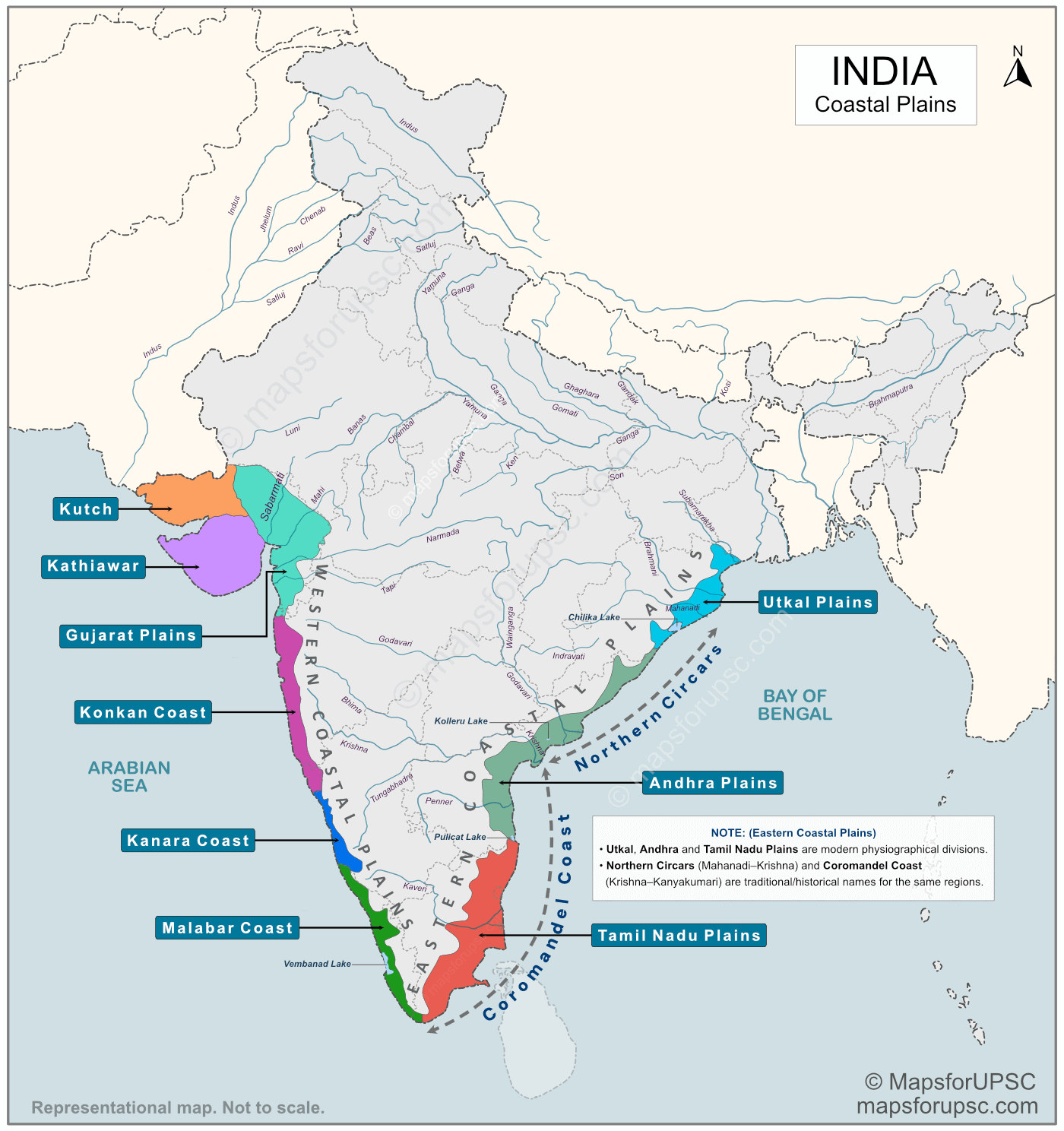
The Coastal Plains of India are narrow stretches of low-lying land found along the coastline of India, between the Peninsular Plateau and the surrounding seas. They are formed mainly by river deposition and marine processes and are among the most fertile and economically important regions of the country.
Based on physiography (physical geography), India’s coastal plains are broadly divided into:
- Eastern Coastal Plains (along the Bay of Bengal)
- Western Coastal Plains (along the Arabian Sea)
Each of these two belts is further subdivided into smaller physiographic units such as the Malabar Coast, Konkan Coast, Utkal Plains, and Andhra Plains.
These subdivisions are explained in detail below, along with their extents, key features, a free downloadable PDF map, and important facts useful for competitive examinations such as UPSC.
Important Note on the Extent of the Malabar Coast:
Different sources mention the southern limit of the Western Coastal Plains in slightly different ways. Many books extend the Western Coastal Plains up to Kanyakumari (Tamil Nadu), while the Malabar Coast is generally considered to lie mainly within present-day Kerala, as shown on the map.
This difference exists because coastal boundaries are not clearly marked natural lines. Some authors follow physical (physiographic) features, while others use state boundaries for convenience. Both views are acceptable, and aspirants should focus on the broader geographic understanding rather than minor boundary differences.
Western Coastal Plains of India
The Western Coastal Plains of India extend from Kutch (Gujarat) in the north to Kanyakumari (Tamil Nadu) in the south. They are generally narrow and lie between the Western Ghats and the Arabian Sea.
General Characteristics:
- Much narrower than the Eastern Coastal Plains, mainly because the Western Ghats run almost parallel and very close to the Arabian Sea, leaving only a thin strip of land in between.
- Traverses the states of Gujarat, Maharashtra, Goa, Karnataka and Kerala + Union Territories of Puducherry (Mahe) and Dadra & Nagar Haveli and Daman & Diu.
- Land has a steep slope towards the sea, resulting in fast river flow
- Most of the rivers are short and swift, originating from the Western Ghats
- Absence of major deltas due to steep gradient and strong sea waves
- Rivers mainly form estuaries instead of deltas
- Presence of backwaters and lagoons, especially in Kerala (e.g., Vembanad Lake)
- Receives heavy rainfall from the Southwest Monsoon
The Western Coastal Plains are broadly divided into six subdivisions:
- Kutch
- Kathiawar
- Gujarat Plains
- Konkan Coast
- Kanara Coast
- Malabar Coast
1. Kutch
- Located in north-western Gujarat, near the India–Pakistan border.
- Includes the Rann of Kutch, a vast saline marsh, which gets partly submerged during high tides and monsoon flooding.
- Divided into Great Rann and Little Rann of Kutch.
- Known for large-scale salt production and unique desert–wetland ecology.
- Ecologically important for mangroves, wetlands and migratory birds (e.g., flamingos).
- A seismically active and earthquake-prone region (e.g., 2001 Bhuj earthquake).
- Important coastal features include the Gulf of Kutch and several creeks that support ports, fisheries and maritime trade.
2. Kathiawar
- A peninsula located south of Kutch in Gujarat, extending into the Arabian Sea.
- Bounded by the Gulf of Kutch (north) and the Gulf of Khambhat (east).
- Characterised by an undulating plateau with short rivers.
- Coastal areas include marine national parks, important ports (e.g., Okha, Porbandar) and industrial centres.
- Known for coastal agriculture, especially cotton and groundnut cultivation.
- Home to the Gir Forest, the only natural habitat of the Asiatic Lion.
- The coastline is rocky and irregular, with several creeks and inlets, supporting fishing activities.
3. Gujarat Plains
- A low-lying coastal belt along the Gulf of Khambhat and adjoining parts of Gujarat.
- Formed mainly by alluvial deposits of rivers such as Narmada, Tapi, Mahi and Sabarmati.
- Characterised by tidal flats, estuaries and mudflats, with some areas prone to coastal flooding and salinity intrusion.
- Experiences high tidal range, especially in the Gulf of Khambhat.
- An important industrial and agricultural region, with major ports such as Bhavnagar and Surat.
- Noted for petrochemical industries, refineries and coastal trade activities.
4. Konkan Coast
- A narrow coastal strip extending from Daman (north) to Goa, lying mainly in Maharashtra and Goa.
- Sandwiched between the Western Ghats and the Arabian Sea, resulting in very limited flat land.
- Characterised by deeply dissected hills, rocky cliffs and numerous small estuaries.
- Rivers are short and swift, forming estuaries rather than deltas.
- Major ports and cities include Mumbai, Ratnagiri and Mormugao (Goa).
- Important crops: rice, coconut, arecanut and cashew; also known for fisheries and coastal tourism (Goa beaches).
- Region is dominated by laterite soils and receives heavy southwest monsoon rainfall.
5. Kanara Coast
- Extends along the Karnataka coast, from the Goa border in the north to the Mangalore region in the south.
- A narrow coastal strip between the Western Ghats and the Arabian Sea.
- Marked by numerous short rivers such as Sharavati and Netravati, forming estuaries at their mouths.
- Receives heavy southwest monsoon rainfall, supporting dense tropical evergreen and moist deciduous forests on nearby slopes.
- Known for features like Jog Falls (Sharavati River) in the adjoining Ghats.
- Economy based on fishing, ports (New Mangalore), shipbuilding, iron-ore export and plantation crops.
6. Malabar Coast
- Extends from southern Karnataka through Kerala up to Kanyakumari.
- Comparatively wider coastal plain than the Konkan and Kanara coasts.
- Famous for its backwaters and lagoons such as Vembanad and Ashtamudi, separated from the sea by sand bars.
- Numerous short west-flowing rivers form estuaries and backwater systems.
- Receives very heavy southwest monsoon rainfall, supporting dense settlements and extensive paddy fields.
- Important crops: rice, coconut, rubber and spices (pepper, cardamom, cloves).
- Major ports and cities include Kochi, Kozhikode and Kollam; region is significant for tourism, fisheries and inland water transport.
Eastern Coastal Plains of India
The Eastern Coastal Plains extend from the Utkal region of Odisha (near the West Bengal–Odisha border) in the north to Kanyakumari in the south, along the Bay of Bengal. Compared to the Western Coastal Plains, they are broader, flatter and more fertile, mainly due to the deposition of sediments by large east-flowing rivers.
General Characteristics:
- Extend along the Bay of Bengal from Odisha to Kanyakumari.
- Wider and more extensive than the Western Coastal Plains.
- Formed largely by alluvial deposits of major rivers such as Mahanadi, Godavari, Krishna and Kaveri.
- Characterised by broad river deltas, sandy beaches and lagoons.
- Represent a largely emerged coast (depositional in nature).
- Rivers are long and slow-moving, forming large and fertile deltaic plains.
- Highly fertile region, supporting intensive rice cultivation (often called the rice bowl in parts).
- Home to major ports and industrial–urban centres such as Chennai and Visakhapatnam.
- More prone to cyclones, storm surges and flooding, especially along the northern and central stretches.
The Eastern Coastal Plains are broadly divided into three subdivisions:
- Utkal Plains
- Andhra Plains
- Tamil Nadu Plains
Important Note:
The divisions Utkal Plains, Andhra Plains and Tamil Nadu Plains represent the modern physiographical classification of the Eastern Coastal Plains based on physical geography.
The terms Northern Circars (Mahanadi–Krishna) and Coromandel Coast (Krishna–Kanyakumari) are traditional or historical names used in older literature for largely the same coastal stretches.
For examination purposes, aspirants should prefer the modern physiographical divisions, while also being familiar with the traditional names, as both may appear in different sources or questions.
1. Utkal Plains
- Coastal plains of Odisha and adjoining northern Andhra Pradesh.
- Dominated by the deltas of the Mahanadi, Brahmani, Baitarani and Subarnarekha rivers.
- Characterised by broad, low-lying alluvial plains with sandy beaches and coastal lagoons.
- Contain Chilika Lake, a large brackish water lagoon separated from the sea by a sand bar; important for migratory birds, fisheries and biodiversity.
- Highly fertile and suitable for intensive rice cultivation.
- Frequently affected by cyclones, storm surges and riverine flooding due to its low elevation.
- Important ports include Paradip, Dhamra and Gopalpur, supporting trade and industry.
- Forms the northern part of the traditional “Northern Circars” region.
2. Andhra Plains
- Extend along the coastal belt of Andhra Pradesh, from the southern margin of the Utkal Plains up to Pulicat Lake in the south.
- Dominated by the Godavari and Krishna deltas, among the largest and most fertile deltaic regions of India.
- Characterised by broad, flat alluvial plains with extensive canal and irrigation networks.
- Include Kolleru Lake, a large freshwater lake located between the Godavari and Krishna deltas.
- Known for intensive rice cultivation, making it one of the major food-grain producing regions of South India.
- Important urban and port centres include Visakhapatnam, Kakinada, and Machilipatnam.
- Highly vulnerable to cyclones, storm surges and coastal flooding from the Bay of Bengal.
- Along with the Utkal Plains, it formed part of the historical Northern Circars region.
3. Tamil Nadu Plains
- Extend along the coastal plains of Tamil Nadu, from Pulicat Lake in the north to Kanyakumari in the south.
- Dominated by the Cauvery (Kaveri) delta, along with smaller river deltas.
- Characterised by sandy beaches and a relatively straight coastline.
- The Cauvery delta is one of the most fertile regions of Tamil Nadu and is often called the “granary of the state.”
- Major urban centres and ports include Chennai, Nagapattinam and Thoothukudi (Tuticorin).
- Major crops: rice, sugarcane, groundnut and cotton, supported by river irrigation and traditional tank systems.
- Vulnerable to cyclones, storm surges and the Northeast Monsoon rainfall.
Traditional/Historical Coastal Names
1. Northern Circars
- Historical name for the coast from Mahanadi delta to around Krishna delta.
- Today covers parts of Utkal Plains and northern Andhra Plains.
- Formerly important for colonial trading posts and ports.
2. Coromandel Coast
- Traditional name for the south‑eastern coast from around Krishna delta to Kanyakumari.
- Largely coincides with Tamil Nadu Plains and southern part of Andhra coast.
- Historically a major European trading region (Masulipatnam, Nagapattinam, Madras).
Summary Table: Coastal Plains of India
| Coast / Plain | Stretch (North → South) | Key Features |
|---|---|---|
| Kutch | Rann of Kutch region (NW Gujarat) | Saline marsh; Salt production; earthquake-prone |
| Kathiawar | South of Kutch between Gulf of Kutch & Gulf of Khambhat | Saurashtra Peninsula; Gir Forest (Asiatic Lion) |
| Gujarat Plains | Gulf of Khambhat coastal belt | High tidal range; Narmada–Tapi estuaries |
| Konkan Coast | Daman → Goa | Very narrow coastal strip; Mumbai port, laterite soils |
| Kanara Coast | Goa border → Mangalore | Numerous short estuarine rivers; Sharavati (Jog Falls) |
| Malabar Coast | Southern Karnataka → Kanyakumari | Backwaters & lagoons; Vembanad Lake; heavy SW monsoon |
| Utkal Plains | Subarnarekha → Chilika Lake | Mahanadi delta; Chilika Lagoon; cyclone-prone |
| Andhra Plains | South of Chilika → Pulicat Lake | Godavari–Krishna deltas; Rice bowl region; Kolleru Lake |
| Tamil Nadu Plains | Pulicat Lake → Kanyakumari | Cauvery delta; NE monsoon |
Significance of the Coastal Plains of India
- Among the most fertile regions of India, supporting intensive cultivation of rice and other crops.
- Major centres of agriculture, fisheries and plantation crops, especially along deltaic and backwater regions.
- Host several important ports and coastal cities such as Mumbai, Kochi, Chennai and Visakhapatnam, playing a key role in international trade.
- Support large industrial and petrochemical hubs, particularly along the Gujarat and Tamil Nadu coasts.
- Important for inland water transport and tourism, especially in the backwaters of Kerala and the beaches of Goa and Tamil Nadu.
- Ecologically significant due to mangroves, wetlands, lagoons and estuaries, which support rich biodiversity.
- Strategically important for maritime security, naval bases and coastal infrastructure.
- Highly vulnerable to cyclones, coastal erosion, flooding and sea-level rise, making them important from a disaster management perspective.
