The Northern Plains of India are vast stretches of flat, low-lying land formed by the deposition of alluvium brought by the Indus, Ganga, and Brahmaputra river systems. They extend across northern India and form one of the six major physiographic divisions of the country.
Due to the dominance of these river systems, the region is also referred to as the Indo-Gangetic Plains or the Indo-Gangetic-Brahmaputra Plains.
These plains are among the most fertile and densely populated regions of India, supporting extensive agriculture and major human settlements. Their formation is closely linked to the Himalayan rivers, which continuously deposit sediments, making the region both dynamic and agriculturally productive.
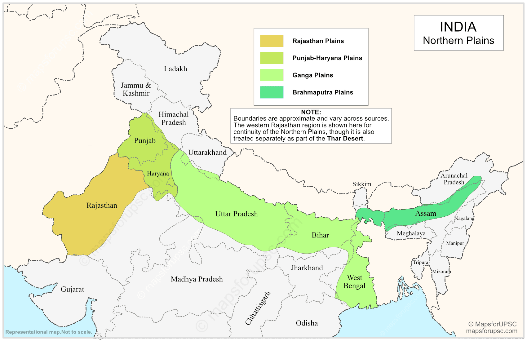
Based on physiography, the Northern Plains of India are broadly divided into:
- Rajasthan Plains
- Punjab–Haryana Plains
- Ganga Plains
- Brahmaputra Plains

Northern Plains of India: Features
| Aspect | Details |
|---|---|
| Formation | The Northern Plains were formed by the deposition of alluvial sediments brought down mainly by the Indus, Ganga, and Brahmaputra river systems. Over a long geological period, these rivers carried silt, sand, and clay from the Himalayas and deposited them in the foreland basin, creating a vast plain. |
| Origin | They are fluvial in origin, meaning they were created by river action rather than by tectonic uplift or volcanic processes. |
| Boundaries | The plains are bounded by the Himalayan foothills (Shiwalik range) to the north, the Thar Desert and adjoining arid tracts to the west, the Peninsular Plateau to the south, and the Purvanchal Hills to the east. |
| Relief | The region has a broad, low-lying surface with very gentle slope, making it one of the flattest physiographic regions of India. |
| Soil | The plains are covered with deep alluvial soil, which is highly fertile and suitable for agriculture. |
| Rivers | A dense network of rivers, tributaries, and distributaries flows through the region, especially in the Ganga and Brahmaputra plains. |
| Agriculture | The fertile soil, level land, and availability of water make the region ideal for intensive farming and irrigation. |
| Population | Due to favorable physical conditions, the Northern Plains of India support a very large and dense population. |
| Transport | Flat terrain allows easy construction of roads, railways, and canals, so transport and communication are well developed. |
| River Activity | Rivers in the plains frequently form meanders, oxbow lakes, floodplains, levees, and other depositional features. |
| Flooding | Some parts, especially the eastern plains, are prone to floods because of heavy rainfall, silt deposition, and shifting river courses. |
Regional Divisions of the Indo-Gangetic Plains
The Northern Plains (Indo-Gangetic Plains) are broadly divided into four major regional divisions: the Rajasthan Plain, Punjab–Haryana Plain, Ganga Plain, and Brahmaputra Plain. These divisions differ in extent, river systems, relief, and the nature of alluvial deposits, so they are best understood separately.
1. Rajasthan Plain
The Rajasthan Plain forms the western edge of the Indo-Gangetic Plains and is the most arid part of the region. It includes the Thar or Great Indian Desert and adjoining semi-arid tracts, and extends across western Rajasthan, with continuation toward Pakistan on the western side.
- The Marusthali is the true desert core of this region, characterized by shifting sand dunes, sparse drainage, and very low rainfall.
- The eastern part of Marusthali is comparatively rocky, while the western part is dominated by shifting dunes called dhrians.
- The Rajasthan Bagar is the semi-arid transitional belt between the Thar Desert and the Aravalli Range.
- Short seasonal streams from the Aravallis create small fertile patches called rohi.
- The Luni River is the main drainage system of the region, flowing southwest into the Rann of Kutch.
- North of the Luni lies a sandy tract locally called thali.
- Important saline lakes such as Sambhar, Didwana, and Khatu are found in this region.
2. Punjab–Haryana Plain
The Punjab–Haryana Plain lies east and northeast of the Rajasthan Plain and is one of the most fertile parts of the Northern Plains. It is formed mainly by the alluvium of the Satluj, Beas, Ravi, Chenab, Jhelum, and related river systems, and is known for intensive agriculture.
- The plain has a very gentle slope toward the southwest, so rivers generally follow that direction.
- The average length of the plain is about 640 km, and its width is around 300 km.
- The plain is highly suitable for irrigation and canal-based agriculture.
- The northern foothill belt has been intensely eroded by seasonal streams called chos.
- The plain is marked by doabs, or tracts lying between two rivers.
- The five major doabs are:
- Bist-Jalandhar Doab: between Beas and Satluj.
- Bari Doab: between Beas and Ravi.
- Rachna Doab: between Ravi and Chenab.
- Chaj Doab: between Chenab and Jhelum.
- Sind Sagar Doab: between Jhelum-Chenab and the Indus.
- Floodplain areas near riverbanks formed by fresh alluvium are known as bet lands.
- Broad khadar floodplains bordered by bluffs are called dhayas.
- In parts of Punjab, the fertile khadar-rich floodplains are also referred to as bet lands.
3. Ganga Plain
The Ganga Plain is the largest and most fertile division of the Indo-Gangetic Plains, covering about 3.75 lakh sq. km. It extends from the western plains near Delhi to the eastern parts of India up to West Bengal, and slopes generally toward the east and southeast.
3.1 Upper Ganga Plain
The Upper Ganga Plain lies in the western part of the Ganga Plain, mainly across western Uttar Pradesh. It is bounded by the Shiwaliks in the north, the Peninsular boundary in the south, and the Yamuna River in the west.
- The gradient is very low, about 25 cm per km, so rivers flow sluggishly.
- Common features include river bluffs, meanders, oxbow lakes, levees, abandoned channels, and sandy bhurs.
- Major units include the Ganga-Yamuna Doab, Rohilkhand Plains, and Avadh Plains.
3.2 Middle Ganga Plain
The Middle Ganga Plain lies east of the Upper Ganga Plain and covers mainly eastern Uttar Pradesh and Bihar.
- The region is highly fertile but also highly flood-prone.
- Rivers frequently change course, producing levees, bluffs, oxbow lakes, marshes, tals, and ravines.
- The Kosi is especially notorious for shifting channels and severe flooding, which is why it is called the “Sorrow of Bihar”.
- Major units include the Ganga-Ghaghara Doab, Ghaghara-Gandak Doab, and Gandak-Kosi Doab (Mithila Plain).
3.3 Lower Ganga Plain
The Lower Ganga Plain extends into eastern Bihar, West Bengal, and most of Bangladesh. It is the deltaic part of the larger plain system and is strongly influenced by depositional processes.
- The region is bounded by the Darjeeling Himalaya in the north, the Bay of Bengal in the south, the Chotanagpur Highlands in the west, and Bangladesh in the east.
- It is dominated by deltaic landforms and includes the Ganga-Brahmaputra Delta, the world’s largest delta.
- The delta is rich in mangroves and supports the Royal Bengal Tiger in the Sundarbans.
4. Brahmaputra Plain
The Brahmaputra Plain lies in northeastern India and is also known as the Brahmaputra Valley or Assam Valley. It is an aggradational plain formed by the depositional work of the Brahmaputra and its tributaries.
- Its boundaries are formed by the Eastern Himalayas of Arunachal Pradesh in the north, Patkai Bum and Naga Hills in the east, Garo-Khasi-Jaintia and Mikir Hills in the south, and the Indo-Bangladesh border / lower Ganga Plain in the west.
- The tributaries coming from the north deposit large amounts of sediment and form alluvial fans.
- Because the tributaries enter the valley abruptly, the river network becomes braided and highly dynamic, producing meanders, sandbars, and ox-bow lakes.
- The region is flood-prone yet highly fertile, making it important for agriculture.
- Majuli Island, often described as the world’s largest riverine island, lies in this plain.
- The valley is also well known for its tea plantations.
Bhabar, Terai, Bhangar, and Khadar
These four are the key geomorphological features of the northern plains and are extremely important for UPSC because they explain the internal structure of the Northern Plains. They are not separate plains in the broad map sense, but key landform zones within the plains.
Bhabar
Bhabar is the narrow, pebble-strewn belt found at the foot of the Shiwalik hills. It is formed by the deposition of coarse materials such as pebbles and gravels brought down by mountain streams.
Because of its coarse texture, the soil here is porous and the streams often disappear underground after reaching this belt. This makes Bhabar dry and less suitable for cultivation.
Important features:
- Narrow belt along the foothills of the Himalayas.
- Made of coarse pebbles, gravels, and porous deposits.
- Streams often sink underground.
- Dry and less fertile.
- Common in the western and central Himalayan foothill zone.
Terai
Terai lies just south of the Bhabar belt. Since the underground streams of Bhabar re-emerge here, the region becomes marshy, wet, and forested in its natural state.
Terai is more fertile than Bhabar and historically supported dense vegetation and wildlife. In many areas, it was cleared for agriculture and settlement, but it still remains one of the wetter parts of the northern plain fringe.
Important features:
- Located south of Bhabar.
- Marshy, moist, and often forested.
- Streams reappear on the surface.
- Highly fertile but naturally swampy.
- Suitable for agriculture after drainage and clearing.
Bhangar
Bhangar is the older alluvial terrace of the Northern Plains. It lies above the level of active floodplains and is generally not affected by regular annual flooding.
Because it is made of older alluvium, Bhangar often contains calcareous nodules known as kankar. It is less fertile than Khadar but still widely used for agriculture and settlement.
Important features:
- Older alluvial plain.
- Lies above flood levels.
- Often contains kankar nodules.
- Less fertile than Khadar.
- Commonly used for cultivation and settlements.
Khadar
Khadar is the newer alluvial floodplain formed by fresh deposits laid down every year or during periodic floods. It lies close to river channels and is usually very fertile.
Because of repeated sediment deposition, Khadar soils are renewed regularly. However, the area is also more exposed to flooding and channel shifts.
Important features:
- New alluvial plain.
- Found near rivers and active floodplains.
- Very fertile due to fresh silt deposition.
- Prone to floods and river migration.
- Important for intensive agriculture.
River Behaviour in the Plains
The rivers of the Northern Plains play a major role in shaping the landscape. In the upper parts, many rivers carry coarse material, while in the lower plains they deposit fine silt, form meanders, and create floodplains.
The rivers in this region often:
- Shift their channels.
- Form meanders, oxbow lakes, and natural levees.
- Deposit alluvium over wide areas.
- Cause floods during the monsoon season.
This constant interaction between erosion, transportation, and deposition makes the Northern Plains a dynamic geomorphic region rather than a static flat surface.
Importance of the Northern Plains
The Northern Plains are extremely important for India’s economy and population geography. Their fertile soils and river systems have supported agriculture for centuries, making them one of the country’s major food-producing regions.
They are also important because:
- They support very high population density.
- They contain major agricultural belts.
- They provide easier routes for transport and communication.
- They have historically supported urban growth and political centres.
- They form the core of the Indo-Gangetic cultural and economic zone.
